Affordability Unlocked and Its Impact (Part 2)

Today, we continue with part 2 of our guest post about Affordability Unlocked by Brian Poteet.

All of the projects we discussed in Part 1will make a dent in Austin’s ever-escalating affordability crisis, but that’s unfortunately all they’ll make – a dent. In 2017, City Council committed to building at least 135,000 housing units over the subsequent decade. Before moving on, I’m compelled to say that this goal is embarrassingly low for the core of a metropolitan area that is adding 50,000 people each year. It implies that the city is entirely indifferent about the vast majority of people moving to live in car-centric suburbs outside of Austin. It also absurdly implies that building 135,000 units before 2028 is enough to stabilize prices.

I could continue this rant for a while, but I’ll leave it at that. Anyway, here’s how we were doing at the end of 2019, before AU came into effect:

From the 2019 Strategic Housing Blueprint Scorecard
Continue reading

West Campus Two Point Ohhhhh Yeahhhhh!

I may have written about West Campus a time or two before. But this time I come not to praise West Campus, but to bury it — in new developments! On Thursday, October 3, Austin’s City Council will consider the biggest changes to the rules that govern a good chunk of West Campus (known as UNO or the University Neighborhood Overlay) since they were initially passed in 2004. The proposed changes would:

Continue reading

The regulations we need to #parktheplinth

Last post, I talked about physical alternatives that would let us #parktheplinth. Or in normal terms, ways to build downtown towers that don’t have giant parking plinths. Before that, I also discussed the regulatory reasons why large parking plinths are common downtown, but much less so in West Campus. So, today, let’s combine the two thoughts: what regulations could we have downtown that would encourage people building towers downtown to use some of those alternatives to parking plinths?

Continue reading

Five Alternatives to Giant Parking Plinths

Last year, I sketched out why downtown has so many huge parking plinths. But another world is possible! Today, we’ll check out alternatives to the plinth. Then, coming soon, we’ll have a look at how regulations could finally #parktheplinth.

The Independent (aka the Jenga Tower) under construction. The open floors are parking, the one with windows above are where the residences start. Photo by Dan Keshet.

Continue reading

Opportunity Kicks

The hottest political topic in Austin right now is a proposal by the owner of the Major League Soccer franchise Columbus Crew to lease space on a city-owned parcel in North Austin. To see the more colorful side of the debate, browse the #MLS2ATX or #SavetheCrew hashtags on twitter:

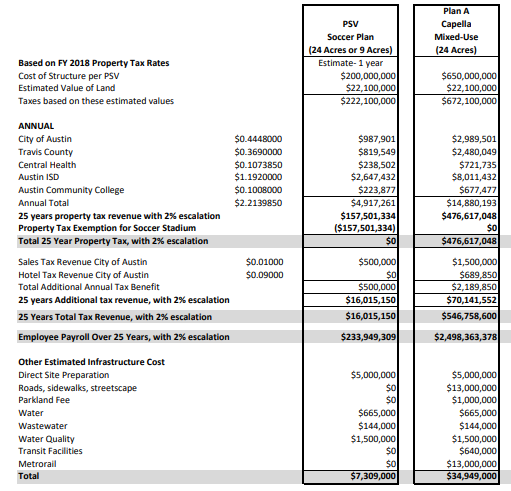
I’m not going to rehash the debate, but rather pick out one piece of the “no” side’s argument, led most strongly by CM Leslie Pool: the opportunity cost of leasing the parcel for a stadium. While the lease would be a financial positive for the city compared to doing nothing on the land, that isn’t the only other option. A nearby property owner/developer, for example, has proposed an alternative plan where they buy the land, build a relatively dense mixed-use development, and pay taxes annually estimated at $15m per year. The “opportunity cost” argument is a really good argument. In fact, this argument is so good that I’ve made it a few times myself over things like the immense value to the city of new construction in West Campus, or the potential opportunity cost of a tax-free convention center annex.  (Proud that the proposal I successfully passed in the Visitor Impact Task Force recommended a future convention center annex remain taxable.) In fact, this is such a great argument that I desperately, desperately wish people used it more often. In a previous policy decision, the decision on what a Planned Unit Development agreement would look like for “the Grove,” a plot of land off 45th Street near Mopac, one of the leading opponents of a similar sort of dense mixed-use development was the very same CM Pool and I don’t recall her carefully weighing the benefits of limiting residences there against the tax revenue the city would forego by allowing more construction.

But the point isn’t to discredit the argument by calling hypocrisy. The argument is really good! It’s an argument worth making! While large developments like the Convention Center annex, McKalla Place, or the Grove are relatively visible because they’re covered in local media and debated by City Council, virtually every land use decision that the city makes has a fiscal dimension, yet we rarely ever think about it. (To his credit, Council Member Flannigan frequently invokes the fiscal impacts of development patterns.)

So, let’s talk about fiscal impacts!

Rule 1: Compact development tends to be more valuable

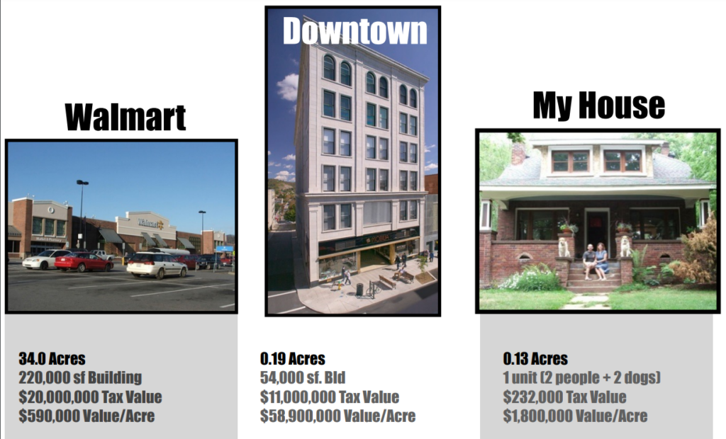
In a fantastic presentation prepared for the Downtown Austin Alliance, consultant Joe Minicozzi compared the fiscal returns to a city from different kinds of development:

While a Walmart may have eye-popping tax values because it’s such a large single development compared to a traditional low-rise office building or house, a low-rise office building also requires much less space to deliver value. Many of a city’s costs, like building streets, scale by the linear mile not by the person. It costs much much more for a city to provide services to a Walmart than to a downtown city block. For residential buildings, the same rules apply. If a city has 5,000 residents, it’s easier to provide them services if they live in a single cluster of 250 acres than if they spread out to 4,000 acres. In Austin, we see these expenses in items like the five fire stations the fire department has requested to cut down response times on the outskirts of the city. I don’t begrudge people who live on the outskirts fire stations. But I do wish we had denser land development patterns in the central city to better take advantage of our existing fire stations and roads.

Rule 2: Value is driven by making great places for the long term

Take a look at the Capella proposal again. In addition to the $15m in annual tax revenues, they will pay other costs: for example, $1m in parkland dedication fees. Additionally, they have offered $22m for the purchase of the land. These types of one-time fees, both voluntary and required, typically dominate policy discussions but they are drops in the bucket compared to the long-term tax revenue from building a great place that could last a century or longer. The financial life-blood of a city is not in one-time fees but recurring taxes levied every year on great places for its residents to live, work, and enjoy themselves.

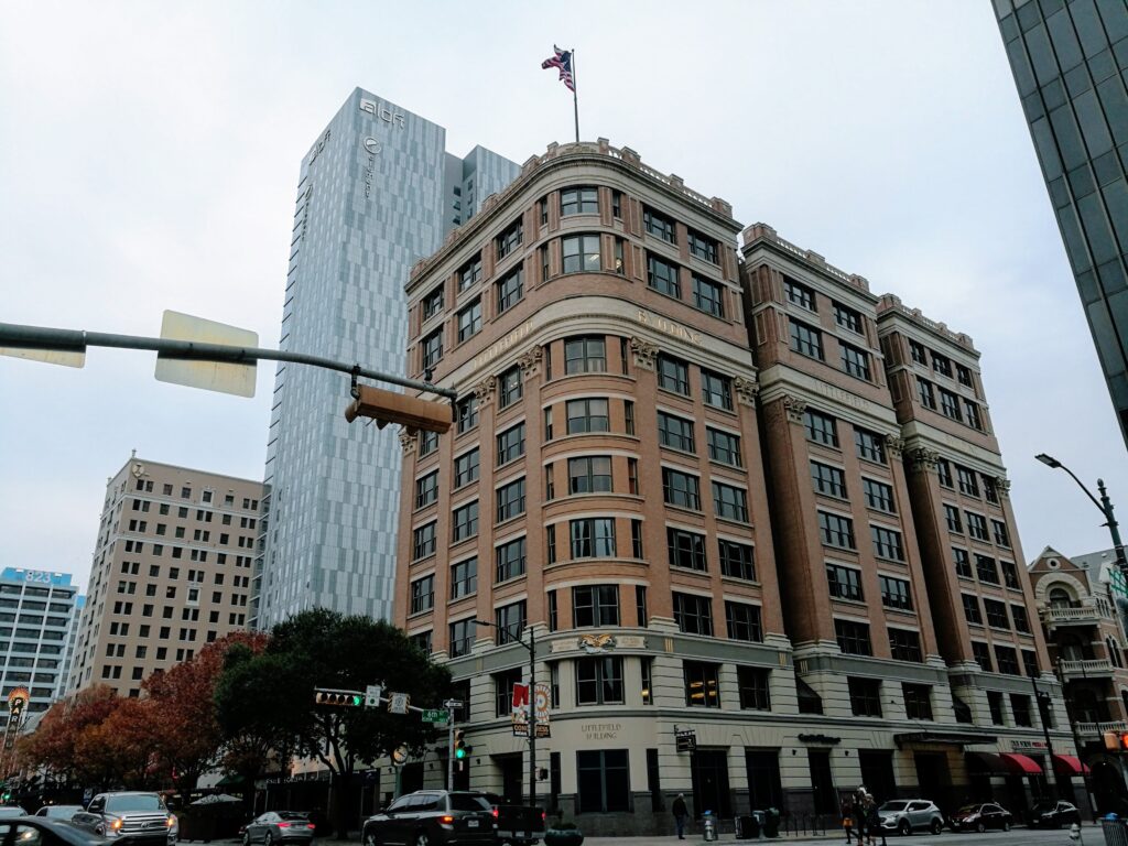
When a city considers the fiscal impact of a development, the question it should be asking itself is not how much can we extract from this developer today but: is this developer making a place that 50 years from now people will still want to be in and still be willing to pay taxes on? The Littlefield and Scarbrough Buildings, two modest 8-story downtown Austin office buildings that were anything but modest at construction time pay close to $1.4m in taxes year-in and year-out more than 100 years after they were built, after their historic building tax breaks!

cof

Rule 3: Taxes are only one of many benefits to consider

Of course, not all of life can be boiled down to profit and loss, tax revenues and maintenance costs. Parks cost taxes to maintain and don’t directly raise taxes themselves, yet most of us love them. Comparing the often difficult-to-quantify benefits with the easy-to-quantify costs can be difficult and frustrating, as both CM Pool and CM Flannigan express here:

There’s no obvious right decision on a given question. Is it worth it to Austin to pay millions of dollars in maintenance and forego even more than that in taxes for things like the Butler Hike and Bike Trail, Zilker Park, or Barton Springs? The overwhelming majority of Austinites would say yes. Is it worth it to Austin to forego millions of dollars in taxes to “bring people together” through a soccer stadium or to prevent dense development on the former TxDOT site? Could it be worth it to create another West Campus, throwing off tens of millions in tax revenue annually to fund things like parks and schools and soccer fields? Austinites are much more split on these questions and that’s why they’re political decisions. But if we want to make good choices, we need to understand the costs and benefits clearly.

Does transportation serve people or do people serve transportation?

No big city has solved either of two problems: making car traffic flow smoothly or making parking simple and cheap. The issue isn’t that governments in every city are bad, though sometimes they are, or that traffic engineers didn’t anticipate the future, though sometimes they didn’t, or that drivers drive too aggressively, though sometimes they do. The issue is that these problems are impossible to solve due to basic geometry. You can fit more people close together than you can fit cars close together. In a small town, you can fit all the people and the cars together without much difficulty. But as a city grows larger, it’s easier to accommodate people, which are relatively small, compared to cars, which are relatively large.

There are a million ways to think about this that all come to the same conclusion. Caleb Pritchard has pointed out that there is more space downtown devoted to parking cars in downtown Austin than there is space in all of downtown (some of the parking spaces, of course, are stacked in multi-level garages, so the math works):

New office buildings in Austin devote as much space to storing cars as they do to storing people.

This is ugly and wasteful and terrible for the environment and extraordinarily expensive. It requires people to spend a long time and sometimes a lot of money circling up floors or circling city streets to find parking spaces and people hate the process with a fiery passion. People’s (un)willingness to circle up floors to park is the binding factor limiting the size and creativity of downtown office buildings in Austin. Car parking is the reason our office buildings are shorter than our residential towers — illustrated nicely by how the Sullivan’s Tower got shorter when it was converted from apartments to office. Car parking is also the reason our office towers are shorter than office buildings in less car-oriented cities like, say, New York or Houston. But despite all that, it kind of works. Every work day, 100,000 people find a place to store 2,000 lbs of metal within a square mile of land, so that they can be close enough together to hold a meeting in the conference room or walk to the courthouse or the state house or the post office or city hall or each other’s offices or any other places they need to go as part of their work day.

As bad as the parking situation can get, it’s good news compared to figuring out the logistics of moving them around the city. We can make many more multilevel parking garages in downtown Austin before we run out of space, but stacking cars on top of one another when they’re driving (by building tunnels or elevated streets) is prohibitively expensive for more than a few major highways. Even then, the best you can hope for is two or maybe three levels that people hate to drive on, look at, or live near. You can widen streets to handle more cars, but the more space you use for streets, the less space you have for the places people are using those streets to go.

Another option is to spread buildings out. Instead of a huge chunk of people coming together to work downtown, make many different employment nodes around the city. This can work, to some degree. But the reasons people needed to be in close proximity to one another don’t go away, so the cure is often worse than the problem. Instead of finding a way to get people who need to be in proximity with one another into a small walkable area, you require them to drive half an hour to get to any meeting they have, creating even more traffic and making things even worse!

There’s simply no solution that allows people to get wherever they want in a big city in a car without facing traffic along the way. Implicitly, when we develop new buildings, our development rules recognize this fact. New buildings are required to perform a “Traffic Impact Analysis” which uses arcane, inaccurate, and context-free rules to model how many times per day somebody will arrive at or leave a building, depending on what kind of things people do inside the building. Rules which require a TIA often limit the number of so-called “trips generated” for a particular development.

The basic idea behind trip generation limits is the understanding that big cities and cars are fundamentally incompatible. Rather than limiting the use of cars, limits on “trips generated” are a vain attempt to limit a city from growing too large to outgrow the usefulness of cars. The reason why this attempt is in vain should be apparent: trips aren’t generated by buildings, but by needs. Sprawling trips out over a bigger area merely forces people to drive even further, creating even more traffic.

Of course, just because cars and big cities have fundamental conflicts doesn’t mean cities can’t continue to outgrow the constraints of car-oriented development. There are countless solutions: buses, trains, bikes, scooters, sidewalks, dollar vans, etc. The details of each solution vary but the overarching idea is very similar: 1) make trips shorter so people don’t need to travel as far to get to the places they want and need to go, and 2) fit people closer together while they’re making trips to make more efficient use of each street.

There have been some positive ideas on reforming TIAs to use these solutions, California being the best example in the US. But I’d like to propose a different way of thinking what a TIA could be. Instead of assuming cities are tied to cars only and then limiting developments to the constraints that cars have, we could start with the development we want and then require that this developments accommodate whatever transportation system is necessary to complement it. Instead of trying and failing to scale cars to a level that they simply aren’t capable of handling, we find the transportation system that is actually capable of handling the development.

For example, if a developer proposes a development whose size or density tips past the point where most trips can be comfortably done with cars, she would be responsible for providing street designs that include different ways of getting around: bike lanes and bike corrals, or designated places to store dockless scooters, or proximity to a transit line.

There is a sense in which we do this already. Austin’s land development code, like many others, requires infrastructure for cars (mostly parking) but allows developers to provide less of it if they provide alternative transportation infrastructure (e.g. parking spaces designated for shared cars like Car2Go, showers for bicyclists). But these efforts are piecemeal and complicated. All too often, TIAs are wielded as weapons to prevent homes and offices, when instead, we could make them a tool to make any development work.

West Campus’ remarkable growth, charted

This blog has something of an obsession with West Campus. It’s the neighborhood that lives by upside-down, inside-out rules and it’s a window into the Austin that could be. So when we got a hold of data about West Campus’ growth, we pretty much had no choice but to put it in charts.

Part 1: Understanding the scale and speed of West Campus’ growth

West Campus has grown fast

Since the creation of the University Neighborhood Overlay in 2004, there has been a pretty steady growth of new homes with a brief financial-crisis-induced break in 2009-2010. The numbers are really quite stupendous: over the course of a decade, essentially a new town of 10K people has been added to what was already one of Austin’s denser neighborhoods.
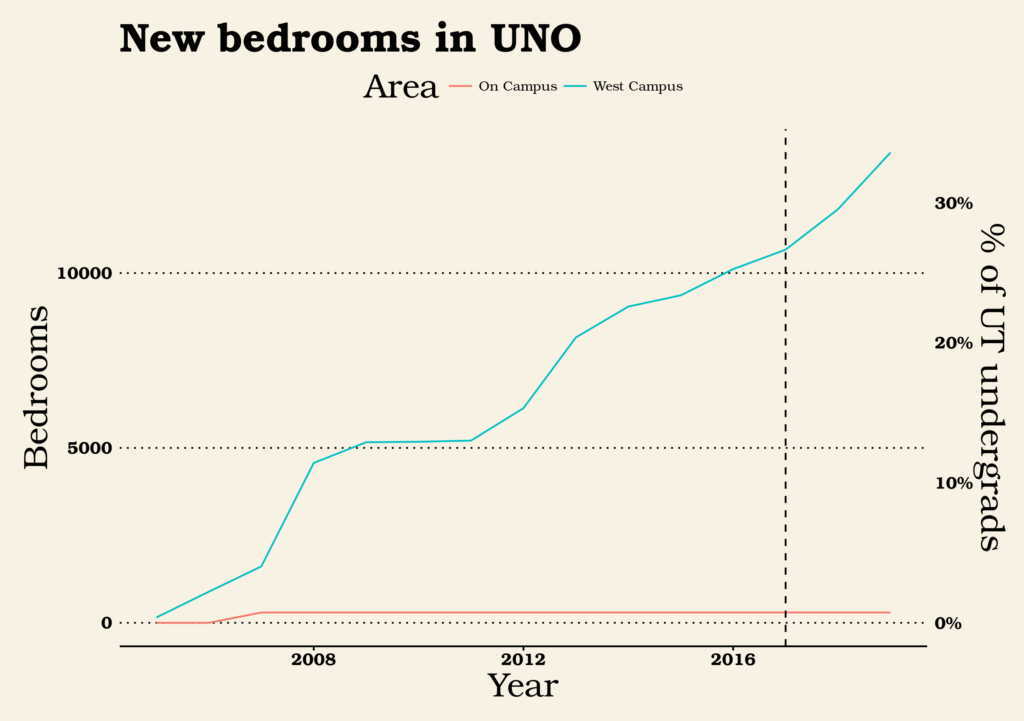
In this chart, I show two equivalent axes: bedrooms (on the left) or % of UT undergrads those bedrooms represent (on the right). I chose to use bedrooms rather than units because of my intuition that student housing is typically occupied by one person per bedroom, so a 4-bedroom unit really does house twice as many people as a 2-bedroom unit. (In other housing, a 4-bedroom unit may mean that one or more bedrooms are being used as a study or guest room.) The blue line shows the number of new bedrooms created in the UNO overlay, while the red line hugging the bottom shows the number of new bedrooms created by new dorms on the UT campus itself. Numbers after 2017 are projections based on city filings rather than completed units on the ground. At the rate UNO is growing, approximately half of UT undergrads will live in new units created under UNO by 2023.

A lot of investment
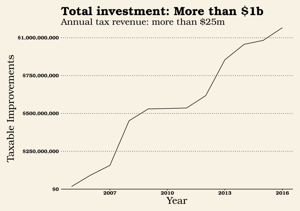
How much does it cost to build out a neighborhood? Using 2017 tax valuation, the UNO buildings alone (not counting the land they sit on) were valued at a bit more than a billion dollars. For comparison, Austin’s last affordable housing bond was for $65m and the capital costs of Austin’s proposed 2014 light rail bond was about $1.5 billion. Each year, the buildings in UNO contribute more than $25m in property tax revenues to the various local government taxing entities: the city of Austin, Travis County, Austin Independent School District, Austin Community College, and Central Health.

A lot of new income-restricted apartments
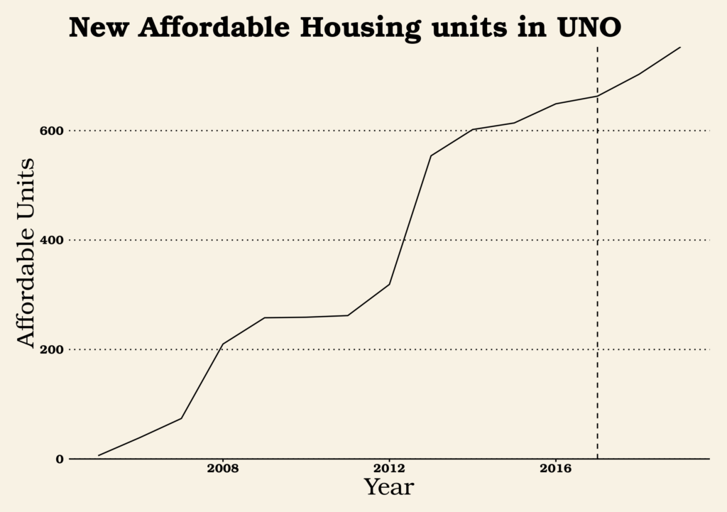
West Campus is home to one of the largest concentration of developments in Austin with apartments specifically for people below certain income levels. There are two reasons for this: 1) as part of the new rules for building apartments, developers are required to set aside a certain number of units for eligible people, and 2) there has been a lot of development in West Campus.

Part 2: How UNO has changed over time

Buildings are getting bigger
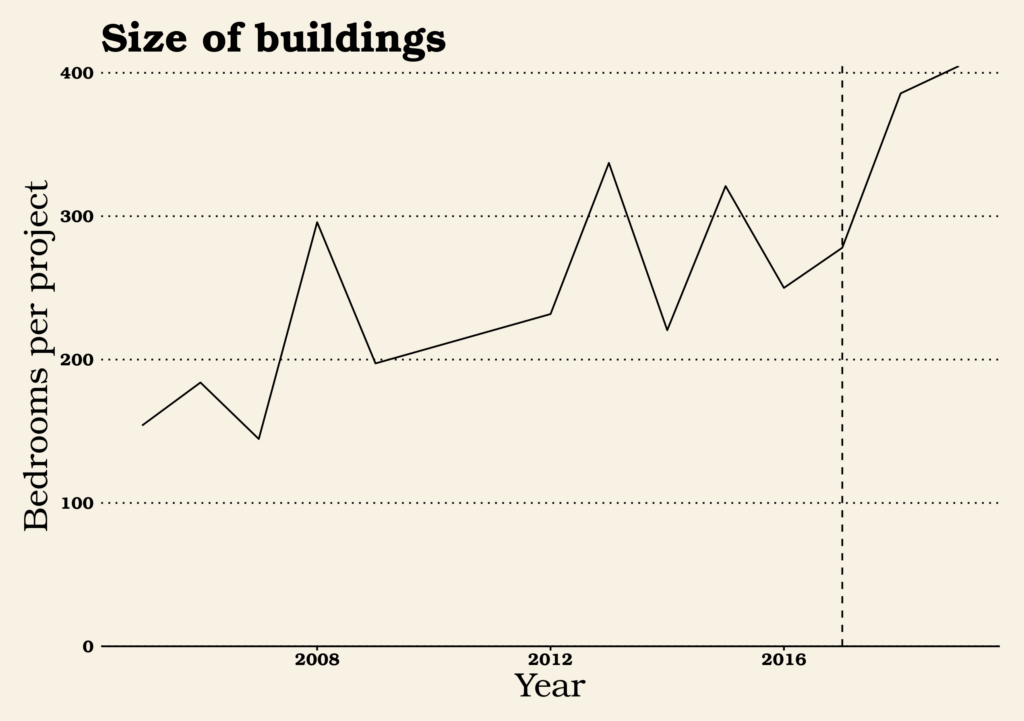
Buildings are getting bigger overall, as expressed by number of bedrooms per project. I’m not sure why this would be; perhaps easier-to-finance mid-rise buildings have proven the way for larger high-rise projects. Perhaps the most easy-to-build sites were in the lower height districts and investors are moving on to the more difficult-to-build sites in high-rise districts.

Parking by bedroom
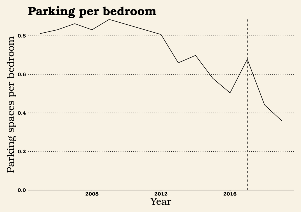
Over time, the number of parking units added per new bedroom built has dropped precipitously from a high of nearly 0.9 parking spaces per bedroom to 0.5 in 2016 and an anticipated 0.36 in 2019. Apparently, when we build places near other places, more people can get around without a car. There’s a number of ways these change might be explained:

  • Developers and financiers have become more comfortable with building less parking as earlier buildings saw less parking used than anticipated.
  • As more commercial amenities have moved into the neighborhood like the Fresh Plus grocery store, fewer students have needed cars.
  • Younger people more generally have lower preferences for having cars with them at school than they used to.
  • Developers have gotten better at managing city rules to find ways to avoid expensive required parking. (More on this later.)

Bedrooms per Unit
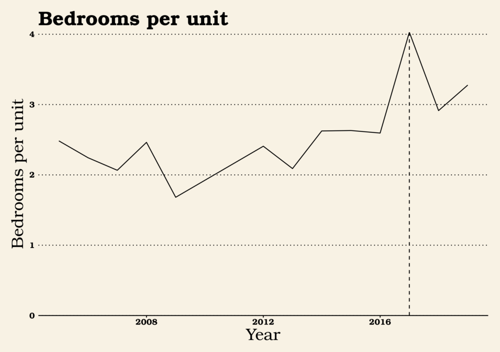
The number of bedrooms provided per unit is a major way that West Campus departs ways from the rest of Austin. Developers typically build studios and 1-bedroom apartments to accommodate the many 1- and 2-person households the city is adding. In West Campus, developers have always built more bedrooms per unit, probably because students are more willing to share a suite with unrelated roommates than many non-students. Of late, though, the  number of bedrooms per unit is going even higher. Why? I have a hunch.

Parking by Unit Size
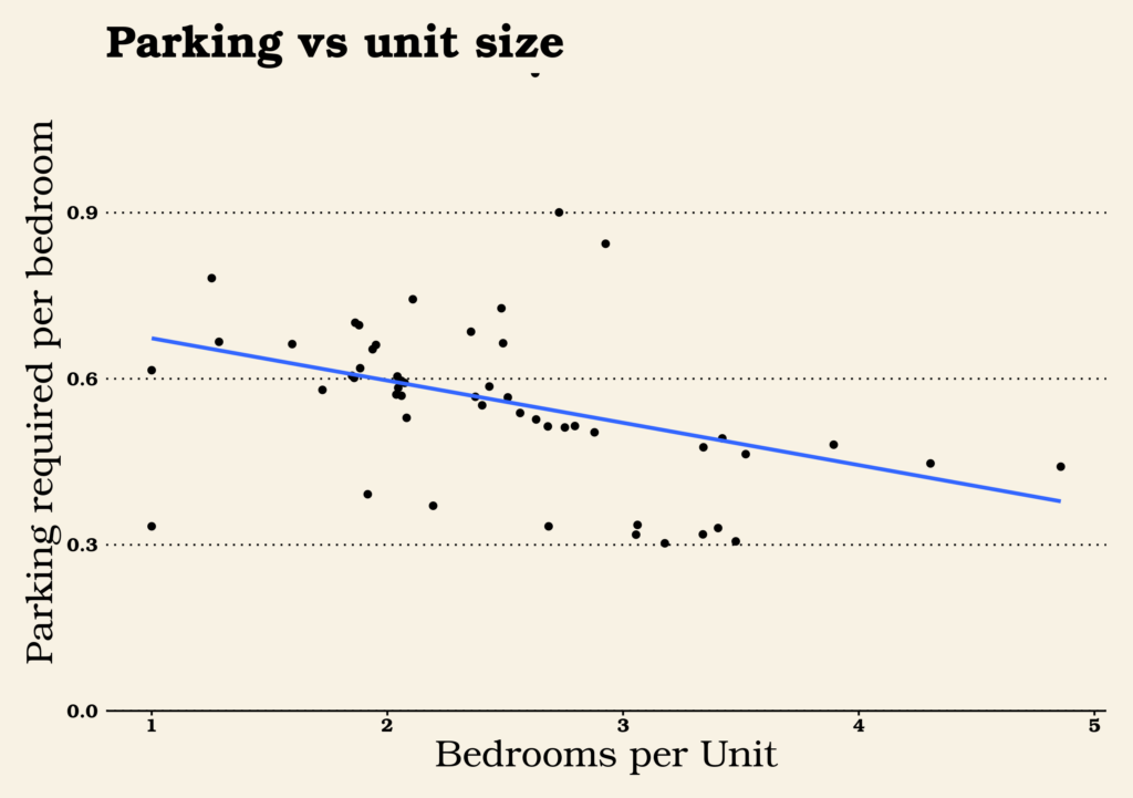
This is a trickier chart than the others. On the bottom axis, there’s bedrooms per unit. On the left axis, there’s parking spaces required (not built) per bedroom. The dots and the blue trend line both show that, generally speaking, the more bedrooms provided per unit, the fewer parking spaces a developer is required to build.

Based on the trend toward less parking per bedroom and more bedrooms per unit, my hunch is that developers have figured out that parking is not an amenity that enough students want or are willing to pay for to justify the fairly high costs of building it. So now they’re trying everything they can to avoid the expense of building unwanted parking garages, including build bigger suites for which they aren’t required to provide as much parking. If this is true, it’s another example of a remarkable property of zoning codes: they always have unintended consequences. Zoning code didn’t set out to decide how many college students should group together into a suite, but it might well have decided it nonetheless.

[Edit: A dissenting view comes in from friend-of-the-blog Tyler Stowell.  See below.]

Conclusions

This has been a fun romp through a little dataset. Let’s reiterate some of the conclusions I’ve drawn:

West Campus shows little signs of slowing down

There are sometimes worries that when a part of town allows denser housing, there will be a big bang as all the most likely sites get developed and the ones that remain all have special problems. If that’s the case with West Campus no effects are obvious. New sites come on to the market all the time and there are still surface parking lots or low-rise buildings that are prime targets for redevelopment. We could well see new West Campus buildings account for 50% or more of the undergrad population before long.

The city still requires too much parking

The trend we observed toward fewer and fewer parking spaces being built — and especially the trend toward weighting the unit mix toward parking-light high-bedroom units — tells me that developers are seeing little use and little market for their parking. With Bcycle rideshare taking off on top of the existing walking, biking, and bus routes, most students in West Campus just don’t want or need cars. Eliminating parking minimums would also allow developers to be more creative in other areas, providing different amenities or lower costs.

The city regulates way more private investment than it makes public investment

So far, rebuilding West Campus has been a $1B project, far dwarfing the amount of money the city has spent directly or indirectly on housing development. Most of the time, we don’t think of it as a single “project” because there is no one single coordinating entity controlling what buildings get built in what order. But it was created as a result of a city policy change. Even the smallest changes to city policy, in this case only affecting a single neighborhood, can end up affecting far more private investment than direct municipal spending affects.

[Note from friend-of-the-blog Tyler Stowell:] I’d disagree with one of your points though – my observation is that the higher bed/unit ratio isn’t a way around parking requirements, it’s a cost cutting measure. Bedrooms are cheap and pay rent. Kitchens and bathrooms are expensive and don’t pay rent. Diluting the cost of kitchens/baths over more beds equals higher profit for the developer. And this works in west campus for college students who might’ve lived in Jester last year. Not so much in other markets. The parking is always a target percentage of bedrooms and truly is market driven (eg. my last project the developer wanted to provide a space for 80% of bedrooms). Some projects take the full reduction allowed by UNO, but some go higher.

6 things to like in California’s proposed transit housing law, illustrated by surfing

On January 4, California felt two earthquakes. The first was a conventional and thankfully weak earthquake in Berkeley:

The second was a political earthquake, emanating from across the bay in San Francisco:

So, here are six things to like about the transit-oriented development bill that’s making waves in state politics:

1 It acknowledges the state has an interest in land use

Many decisions are better made by cities than states. Where will the next branch library go? Should this park have a splash pad or a lawn? But some problems are too big for one city alone, like intercity transportation. If Austin and San Antonio decide to be connected by a train, Buda, Kyle, San Marcos, or New Braunfels should have input (as the train would go through these cities), but they shouldn’t be given a flat veto. It is up to the state government to help manage this process so that local interests in one city don’t hurt local interests everywhere else.

In California and some other states, housing and land use have become problems with statewide and national implications. Housing prices aren’t just high in San Francisco or Los Angeles or even Berkeley; people unable to find housing in those cities are spilling over to suburbs and exurbs all across the state. Whole companies are looking to other states to set up offices because their workers can’t afford California rents. The greenhouse gases from long commutes affect every person on the planet. When a problem is widespread, the solution needs to be widespread too; cities rules by local interests just doesn’t cut it.

When one city’s rules starts to affect not just themselves but others, it can be time for the state to set in and make rules.

2 It creates fair and impartial rules

Laws made at the local level can take into account local context better than statewide rules can be. But laws made at the state level can better take into account the statewide context. In a drought, we need fair rules so that everybody does their part to conserve water and everybody has access to the water they need. In a statewide housing drought, we need fair rules so that everybody does their part to build housing.

Everybody has to play by the same rules.

3 It forges a link between transit and density

In the sphere of YIMBY and placemaking, the problem in California is a very YIMBYish problem: there aren’t enough homes to go around for all the people who want to live in California’s cities. But the solution that Wiener proposes isn’t just focused on getting people into homes anywhere. By proposing rules for allowing more homes near transit, it creates the chance for cities to use this as an opportunity to make great places for the future, where high-capacity transportation solutions are matched with high-capacity housing solutions.

Transit is great because everybody can ride together.

4 It acknowledges how parking rules can hurt housing

One type of land use rule that’s particularly pernicious is the minimum parking regulation. These rules not only incentivize car use by forcing everybody to pay the price of car storage whether they drive or not, they also cut into the budget (both financially and physically) of new housing. This legislation will stop cities from using these pernicious rules near transit stops and opens the possibility for people to find new ways to live cheaper while using less parking.

Not everywhere is perfect for parking.

5 It helps bridge the gap between people and jobs

The problems of California’s cities aren’t their problems alone. Vast swathes of the state are home to unique industries, from Silicon Valley’s tech economy to Hollywood’s movie industry. Sure, tech jobs exists outside Silicon Valley and movies are filmed all over the world. But place has, if anything, grown more important over the last decades, not less. Young workers looking to break into an industry would do well to show up where the jobs are, and new companies looking to start up would do well to show up where the workers are. Today, though, many people are shut out of these engines of prosperity because they can’t afford to live in Palo Alto, San Francisco, or Los Angeles while they lean the trade. Who knows what great technology or film talent we may cherish tomorrow if only we make room for them today?

Some folks in California’s economy find good jobs and places to live while others are simply couch surfing.

6 It might just save humanity

With the United States federal government oriented away from action against climate change, individual states badly need to step up their game. While trying not to overstate the importance of this bill, the fate of the entire human race might depends on our ability to transition the United States and our high-emission society into one in which we can get around more efficiently.

If we don’t address climate change, there’s a wave heading our way that California — and humanity — might not be able to ride out.

So congratulations to Senator Scott Wiener! You brought a proposal that deals with the scale of the problems your state and this country are experiencing, and you may have changed the conversation on housing for good.

Words by Dan Keshet. Gif selection by Susan Somers.

Five Things to Like and Five to Improve for the North Shoal Creek Neighborhood Plan

Susan Somers is a north Austin resident near the North Shoal Creek area, President of urbanist organization AURA, and the genius gif editor who made this blog’s most famous piece pounce.

The city recently released a draft version of the North Shoal Creek Neighborhood Plan. North Shoal Creek is on the far edge of what you might consider north central Austin – bounded by Anderson Lane to the south, Highway 183 to the north, Mopac Boulevard to the west, and Burnet Road to the east. The plan is set to be the first new neighborhood plan in several years and City planning staff seem to have billed it as a kinder, gentler neighborhood plan: one that would try to fulfill the goals of Imagine Austin and identify new opportunities for growth. As such, the draft plan may give us a decent sense of what small area planning would look like if we continue churning out neighborhood plans in the CodeNEXT era.

How does the draft North Shoal Creek plan stack up?

Outline of North Shoal Creek, via the draft plan.

Five things we like

  • The plan acknowledges the reality that apartments are more affordable and single family homes are not. The plan repeatedly points out that the apartments and multifamily condominiums in the neighborhood are more affordable that the single family homes. What’s more, “Apartments and condominiums in North Shoal Creek provide more affordable options relative to much of Austin, while single-family homes are less affordable than the citywide average.” It also acknowledges that the majority of people in the planning area live not in the single family homes of the “Residential Core,” but in apartments along the edges of the neighborhood. Furthermore, it points out that the neighborhood’s residents are aging, and young families are being priced out.
  • The plan prioritizes walkability. Almost half the “needs” and “values” identified by the community involved walkability in some way. The plan calls for new sidewalks and trails, better access to transit stops, and improved safety for schoolchildren walking to Pillow Elementary. It even contemplates innovative ideas such as opening up a pedestrian trail to access Anderson Lane businesses or allowing the community better access to Shoal Creek.

    Hundreds of people live here, but this is not a place that invites walking. Image via Google Maps.
  • The plan allows homes on the neighborhood corridors. The plan acknowledges that retail, particularly along Burnet Road, is dying. It allows for mixed-use development including apartment homes to be built along Burnet Road and Anderson Lane, the neighborhood’s major corridors. It also acknowledges that transit access is a very important reason to allow these homes to be built, and that apartment density should be clustered near transit. While allowing apartments on transit corridors may seem obvious, North Shoal Creek has fought apartment homes in the past, so this is a promising development.
  • The plan supports granny flats (aka “accessory dwelling units”). The plan seems to support allowing homeowners to build granny flats throughout the single family section of the neighborhood. Adding another home to a lot is an easy, almost invisible way to add more housing!
  • The plan envisions an innovative “Buell District.” Buell Avenue is currently dotted with light industrial development like self-storage facilities and auto-repair shops. The plan envisions change along Buell Avenue, including special zoning opportunities like townhouses, small apartments, and live-work spaces that would allow a greater variety of housing into the neighborhood.

Five things to improve

  • Choose some side streets for rowhouses. Other than on Buell Avenue, the plan does not call for allowing missing middle housing types like rowhouses on any side streets. We’ve previously argued rowhouses are an underappreciated and underused housing form in Austin, and CodeNEXT should allow more of them. But over and over again, our planning processes shy away from this awesome type of home. There are plenty of larger neighborhood streets in North Shoal Creek that would be appropriate for rowhouses. The plan leaves the impression that the only reason townhouses would be allowed on Buell is that the neighborhood likes the current light industrial businesses even less than they like rowhouses.

    Rowhouses are a residential type of building and, as such, they belong every bit as much in residential-only areas as areas of mixed use.
  • Multiplexes or small apartments on corner lots. Similarly, other missing middle housing types like multiplexes, small apartments, or cottage courts, are not placed in the “Residential Core,” even on large corner lots. Large corner lots are the perfect place to allow this kind of missing middle.

    This fourplex is one of the last standing of a formerly common missing middle housing type in residential Austin.
  • Sanctity of the “Residential Core.” Let’s talk more about that “Residential Core” phrase. As we note above, the plan acknowledges that the majority of residents live not in the interior of the neighborhood in single family homes, but in apartments on the edges of the neighborhood. Thus, calling the single family section of the neighborhood residential as compared to the corridors is a kind of double speak. Literally, more residents live outside the area termed “residential” in this plan! Based on the plan’s constraints, that pattern will become even more pronounced! Why does this terminology matter? Many other aspects of the plan focus strictly on the “Residential Core.” Three of the six bullet points regarding the goals of the Neighborhood Transition area focus not on making the zone great for its residents but on how not to encroach on the privacy of single family homes. The poorer majority residents are treated as interlopers on the richer minority. In fact, it’s not even clear that the existing apartments in the Neighborhood Transition lots would fit the constraints of the plan.
  • Vision for connectivity/reconnecting streets. Residents in North Shoal Creek have asked for a more walkable neighborhood and for better access to transit stops. One way to make this area, designed with meandering streets and suburban cul-de-sacs, more walkable would be to designate opportunities to acquire lots and reconnect streets separating people from one another. While the plan considers this for connecting homes to retail via urban trails, there are no such connections proposed in the “Residential Core.”

    Google Maps recommends a 17 minute walk along a freeway to walk between these backyard neighbors.
  • Tying desired neighborhood amenities (sidewalks, parks) to opportunities for density. There are many ambitious, desirable aspects of the plan that are unfunded mandates. These unfunded plans include building out the sidewalk network, adding urban trails, developing more parkland, and creating the Shoal Creek trail. The plan acknowledges the challenges of getting funding to make these a reality. But other neighborhoods where these improvements have actually taken place (like Bizarro Austin) have done more than make a wishlist and hope. They created incentives for redevelopment to happen and required developers to fund improvements to the public sphere as part of that redevelopment.

In some ways, the North Shoal Creek draft plan lives up to its kinder, gentler billing. It recognizes the real problems the neighborhood has: from families being priced out to unwalkability impinging on quality of life. The plan promotes the two main fixes we’ve also seen coming out of the latest draft of CodeNEXT: accessory dwelling units and apartment homes on transit corridors. Let us acknowledge that many of Austin’s older neighborhood plans don’t go even this far. However, to truly confront the problems the plan identifies, broader changes are needed, including in areas where the minority of neighborhood residents live. By opening up to a bit more change, some of the truly visionary elements of the plan could be funded and constructed.

The one little rule that decides where Austin’s towers build parking

Not every tower in downtown Austin looks exactly the same, but there is one defining characteristic that describes almost all of them: parking. Most towers rest on top of what they call in the industry a parking plinth, the tower base where folks store their cars. (Plinth is a Swedish word meaning ugly thing.) Here’s a typical example, the Seaholm Tower in southwest downtown.

On the ground floor, there’s a restaurant. Above that, the area with small and sporadic windows is the parking garage. Above that, the area with balconies is where the condos live. Simple, effective, but not always super sightly, at least to my tastes. Why not build parking underground, freeing up aboveground levels for more homes? For one thing, building underground car parking is very expensive. The exact difference varies by site but I’ve seen estimates that moving a parking space underground can add $10K to the cost of the space — and the further you have to dig, the more expensive it gets. So perhaps underground parking is reserved for the most expensive buildings?

No, even in Austin’s newest luxury towers you see aboveground parking:

The Independent (aka the Jenga Tower) under construction. The open floors are parking, the one with windows above are where the residences start.

The Fifth and West Tower’s parking structure (behind the vet’s office) is much wider than the tower above it, which is constrained by capital view corridors.

The parking plinth at the Seven Apartments is again much wider than the building itself. The larger the footprint of the parking structure, the less expensive it is per space and the fewer stories a car needs to climb to reach its space. This reduces incentives to build a taller, thinner structure on the same footprint as the tower itself.

Parking underground is just too expensive for Austin, or so I thought, until Sid Kapur pointed out to me that there is somewhere in Austin building underground parking:

[tweet 938849429121060865]

Yes, of course, West Campus (aka Bizarro Austin) is building underground parking. See James Rambin’s writeup at sister site Austin Towers of projects like Skyloft and Aspen West Campus with four stories of underground parking. So why do developers building student housing decide to put parking underground? Are students more discerning aesthetic connoisseurs? Sorry, students, but I doubt it. I have an alternate theory.

There are many different ways that zoning codes can limit the amount of space that can be built. In downtown, the binding constraint preventing even larger buildings is something called Floor Area Ratio or FAR: roughly, the square footage of climate-controlled space in a building divided by its footprint. In West Campus, the binding constraint on the size of a building is regulations on maximum height. Crucially, parking counts toward a building’s height but doesn’t count toward its FAR. If a developer in West Campus moved their parking from below-ground to above-ground, they would have to remove apartments in order to fit it in, costing them a lot of money in lost rent. Developers downtown, though, don’t have a height limit so building a parking plinth costs less than putting parking underground, doesn’t use up the building’s FAR, and even makes the residential units more valuable by giving them better views.

If my theory is true, it makes some predictions: portions of northern downtown that are slated to be rezoned with height-constrained zoning categories (CC-40 and CC-60) will likely see underground parking, while the FAR-constrained central business district will continue to see parking plinths. Indeed, the condo building I live in downtown was built pre-CodeNEXT but it had height limits imposed as part of the rezoning process and consequently built most of its parking underground: