How West 6th Was Accidentally Fixed for the Age of Scooters (and How to Keep it Fixed)

There’s a new development on West 6th Street downtown. A six-story hotel going by the name “Canopy By Hilton” is being built next to Star Bar, between Nueces and Rio Grande (details at Towers). Space being rather constrained next to the hotel site, the developers have rented space to stage demolition and construction on the street itself, temporarily narrowing 6th Street:

Here’s what 6th Street looked like pre-construction from the perspective of the Google Maps street view car:

Let’s take that and simplify it a little in StreetMix:

Now, let’s look at what it looks like today:

sdr

Let’s simplify that in StreetMix again:

A funny thing happened on my walk home recently. I noticed that there were no cars parked in the parking spots on the left hand side of this picture and a number of people were using it to scoot in. The blocked-off lane was functioning as a buffer between the scooters and car traffic, thus creating a temporary protected lane.

If the city kept this configuration but made it slightly more permanent, here’s what it might look like in StreetMix:

I’ve replaced the car parking on the left with a two-way bike/scooter lane and updated the buffer so that people can use it to park scooters. Also, I threw in some potted plants as buffers to discourage people from using the buffer, by accident or impatience. The buffered area could not only fit scooter and bike parking, but it could do so and still leave room for a few taxi/Lyft pullouts. Is this the ideal configuration of West 6th? No; I definitely think a professional street designer could do better. But it shows how even a very low-dollar intervention could simultaneously remove some of the many annoying and at times dangerous conflicts on downtown streets:

  • Conflicts between people riding scooters and people driving cars
  • Conflicts between people riding scooters and people walking on sidewalks
  • Conflicts between people parking scooters and people walking on sidewalks
  • Conflicts between people getting picked up or dropped off in Uber/Lyft cars and people driving cars, scooters, or bikes.

Of course, just because this configuration wouldn’t cost much money to execute, it doesn’t mean there aren’t non-financial costs:

  • 13 meter spaces are removed from the street, forcing more drivers to pay market rates to park their cars in parking lots or garages.
  • One car-sized lane has been removed from the street, reducing the peak capacity and slowing the time it takes for drivers to get from downtown to Mopac at rush hour.

Conveniently, Austin has more parking downtown than it has land downtown. (This is true because parking spaces are largely stacked on top of one another).

So, the question becomes not one of finance but one of values and vision. Are we a city that values safe, convenient streets for walking, biking, and scooting, as well as driving, or are we a city that can’t wait the additional two minutes to get on Mopac?

Opportunity Kicks

The hottest political topic in Austin right now is a proposal by the owner of the Major League Soccer franchise Columbus Crew to lease space on a city-owned parcel in North Austin. To see the more colorful side of the debate, browse the #MLS2ATX or #SavetheCrew hashtags on twitter:

I’m not going to rehash the debate, but rather pick out one piece of the “no” side’s argument, led most strongly by CM Leslie Pool: the opportunity cost of leasing the parcel for a stadium. While the lease would be a financial positive for the city compared to doing nothing on the land, that isn’t the only other option. A nearby property owner/developer, for example, has proposed an alternative plan where they buy the land, build a relatively dense mixed-use development, and pay taxes annually estimated at $15m per year. The “opportunity cost” argument is a really good argument. In fact, this argument is so good that I’ve made it a few times myself over things like the immense value to the city of new construction in West Campus, or the potential opportunity cost of a tax-free convention center annex.  (Proud that the proposal I successfully passed in the Visitor Impact Task Force recommended a future convention center annex remain taxable.) In fact, this is such a great argument that I desperately, desperately wish people used it more often. In a previous policy decision, the decision on what a Planned Unit Development agreement would look like for “the Grove,” a plot of land off 45th Street near Mopac, one of the leading opponents of a similar sort of dense mixed-use development was the very same CM Pool and I don’t recall her carefully weighing the benefits of limiting residences there against the tax revenue the city would forego by allowing more construction.

But the point isn’t to discredit the argument by calling hypocrisy. The argument is really good! It’s an argument worth making! While large developments like the Convention Center annex, McKalla Place, or the Grove are relatively visible because they’re covered in local media and debated by City Council, virtually every land use decision that the city makes has a fiscal dimension, yet we rarely ever think about it. (To his credit, Council Member Flannigan frequently invokes the fiscal impacts of development patterns.)

So, let’s talk about fiscal impacts!

Rule 1: Compact development tends to be more valuable

In a fantastic presentation prepared for the Downtown Austin Alliance, consultant Joe Minicozzi compared the fiscal returns to a city from different kinds of development:

While a Walmart may have eye-popping tax values because it’s such a large single development compared to a traditional low-rise office building or house, a low-rise office building also requires much less space to deliver value. Many of a city’s costs, like building streets, scale by the linear mile not by the person. It costs much much more for a city to provide services to a Walmart than to a downtown city block. For residential buildings, the same rules apply. If a city has 5,000 residents, it’s easier to provide them services if they live in a single cluster of 250 acres than if they spread out to 4,000 acres. In Austin, we see these expenses in items like the five fire stations the fire department has requested to cut down response times on the outskirts of the city. I don’t begrudge people who live on the outskirts fire stations. But I do wish we had denser land development patterns in the central city to better take advantage of our existing fire stations and roads.

Rule 2: Value is driven by making great places for the long term

Take a look at the Capella proposal again. In addition to the $15m in annual tax revenues, they will pay other costs: for example, $1m in parkland dedication fees. Additionally, they have offered $22m for the purchase of the land. These types of one-time fees, both voluntary and required, typically dominate policy discussions but they are drops in the bucket compared to the long-term tax revenue from building a great place that could last a century or longer. The financial life-blood of a city is not in one-time fees but recurring taxes levied every year on great places for its residents to live, work, and enjoy themselves.

When a city considers the fiscal impact of a development, the question it should be asking itself is not how much can we extract from this developer today but: is this developer making a place that 50 years from now people will still want to be in and still be willing to pay taxes on? The Littlefield and Scarbrough Buildings, two modest 8-story downtown Austin office buildings that were anything but modest at construction time pay close to $1.4m in taxes year-in and year-out more than 100 years after they were built, after their historic building tax breaks!

cof

Rule 3: Taxes are only one of many benefits to consider

Of course, not all of life can be boiled down to profit and loss, tax revenues and maintenance costs. Parks cost taxes to maintain and don’t directly raise taxes themselves, yet most of us love them. Comparing the often difficult-to-quantify benefits with the easy-to-quantify costs can be difficult and frustrating, as both CM Pool and CM Flannigan express here:

There’s no obvious right decision on a given question. Is it worth it to Austin to pay millions of dollars in maintenance and forego even more than that in taxes for things like the Butler Hike and Bike Trail, Zilker Park, or Barton Springs? The overwhelming majority of Austinites would say yes. Is it worth it to Austin to forego millions of dollars in taxes to “bring people together” through a soccer stadium or to prevent dense development on the former TxDOT site? Could it be worth it to create another West Campus, throwing off tens of millions in tax revenue annually to fund things like parks and schools and soccer fields? Austinites are much more split on these questions and that’s why they’re political decisions. But if we want to make good choices, we need to understand the costs and benefits clearly.

Laycock: Jump e-bikes help me get around Austin better

Today’s post is a guest post from friend-of-the-blog John Laycock. He has allowed us to reprint a letter he sent to city staff and City Council.
I am writing to let you know how great the dockless pilot has been for me. I live at the MLK transit-oriented development (District 1), by the MLK Red Line station, and I don’t own a car. I have a mild disability that limits how far I can walk; I can regular bike, but anything more than a small hill is challenging to me. I am accustomed to and comfortable to using the train, the bus, my feet, my own bike, and B-Cycle, but I can say that Jump e-bikes have already changed my life by improving my mobility options. The train is a really good way to get around. But the train has limited hours – it’s easy for me to get downtown or to my job when it’s running, and much more difficult when it’s not. I’m still fairly close to both UT and downtown; the dockless e-bikes are great because they make a trip of 2-3 miles very convenient.

The e-bikes also solve the last mile problem with transit. This is a well-known issue, and I just want to give a few examples: yesterday, I wanted to go to One Texas Center. I took the train to downtown station, and was literally all but the last mile there. I’ve done this many times, and there are four ways to get that last mile: 1) walk 2) walk to 4th and Guadalupe and transfer to the bus; 3) B-cycle, 4) Ride Share. The e-bike is faster than all of them: cheaper than rideshare, easier, faster, and more comfortable than the other three options.  There’s really no comparison.
Another example is I was at 30th and Guadalupe trying to get home to 1601 Miriam. It’s just under 3 miles, but a difficult journey. Too far to walk, and awkward to bus. (Half mile to and from the 20 or take the 1 and transfer to the 18, and 1/3 mi walk). An e-bike was much better: about an 18 minute ride with no wait and door to door service. There are hills on Dean Keeton, but the e-assist made it easy to traverse them. The dockless e-bike took a trip that was a huge challenge and made it almost as easy as a car ride.

Some other observations:
  • I could buy my own e-bike, but it’s really nice to not have to be responsible for a bike all day, especially since I’m using a variety of other modes, like the bus, the train, and rideshare.
  • I have yet to see any dockless vehicles left in such a way as to impede a wheelchair. I see other obstacles on a daily basis. I’ve been wheelchair bound before, so I’m sensitive to the issue.
  • There’s a family in my neighborhood with a ten year old girl; she’s just starting to learn to ride her bike. Her dad doesn’t own a bike, so he’s been renting dockless bikes so he can ride with her and help her to learn. It’s really cute, and a totally unexpected consequence of having dockless bikes. I’ve also seen parents and kids riding e-bikes together downtown.
  • I love the Third Street protected bike lane and I’ve seen a lot of scooters and e-bikes on it in addition to regular bikes. It’s great, but there needs to be an equivalent north-south protected lane.
dig
Anyway, I’m sure there will be snags, but I see the dockless vehicles as a huge boon to mobility in the city. And not just for the people who ride them: imagine going to an event at the Long Center; you might not take a scooter or a Jump Bike, but every family that does frees up one more parking space for you.
I would ask that you continue the dockless pilot, expand the study area, and work with the companies to troubleshoot what problems come up. In the long term, please continue to invest in infrastructure solutions that accommodate non-car modes. Implement the Austin bike plan: it will help both cyclists and dockless users. If necessary, free up additional right of way downtown for cyclists and dockless. And finally, promote them; be excited: this could be a mobility revolution. It has already transformed my life; it could transform the city’s if you let it.
Thank you for your consideration.

Does transportation serve people or do people serve transportation?

No big city has solved either of two problems: making car traffic flow smoothly or making parking simple and cheap. The issue isn’t that governments in every city are bad, though sometimes they are, or that traffic engineers didn’t anticipate the future, though sometimes they didn’t, or that drivers drive too aggressively, though sometimes they do. The issue is that these problems are impossible to solve due to basic geometry. You can fit more people close together than you can fit cars close together. In a small town, you can fit all the people and the cars together without much difficulty. But as a city grows larger, it’s easier to accommodate people, which are relatively small, compared to cars, which are relatively large.

There are a million ways to think about this that all come to the same conclusion. Caleb Pritchard has pointed out that there is more space downtown devoted to parking cars in downtown Austin than there is space in all of downtown (some of the parking spaces, of course, are stacked in multi-level garages, so the math works):

New office buildings in Austin devote as much space to storing cars as they do to storing people.

This is ugly and wasteful and terrible for the environment and extraordinarily expensive. It requires people to spend a long time and sometimes a lot of money circling up floors or circling city streets to find parking spaces and people hate the process with a fiery passion. People’s (un)willingness to circle up floors to park is the binding factor limiting the size and creativity of downtown office buildings in Austin. Car parking is the reason our office buildings are shorter than our residential towers — illustrated nicely by how the Sullivan’s Tower got shorter when it was converted from apartments to office. Car parking is also the reason our office towers are shorter than office buildings in less car-oriented cities like, say, New York or Houston. But despite all that, it kind of works. Every work day, 100,000 people find a place to store 2,000 lbs of metal within a square mile of land, so that they can be close enough together to hold a meeting in the conference room or walk to the courthouse or the state house or the post office or city hall or each other’s offices or any other places they need to go as part of their work day.

As bad as the parking situation can get, it’s good news compared to figuring out the logistics of moving them around the city. We can make many more multilevel parking garages in downtown Austin before we run out of space, but stacking cars on top of one another when they’re driving (by building tunnels or elevated streets) is prohibitively expensive for more than a few major highways. Even then, the best you can hope for is two or maybe three levels that people hate to drive on, look at, or live near. You can widen streets to handle more cars, but the more space you use for streets, the less space you have for the places people are using those streets to go.

Another option is to spread buildings out. Instead of a huge chunk of people coming together to work downtown, make many different employment nodes around the city. This can work, to some degree. But the reasons people needed to be in close proximity to one another don’t go away, so the cure is often worse than the problem. Instead of finding a way to get people who need to be in proximity with one another into a small walkable area, you require them to drive half an hour to get to any meeting they have, creating even more traffic and making things even worse!

There’s simply no solution that allows people to get wherever they want in a big city in a car without facing traffic along the way. Implicitly, when we develop new buildings, our development rules recognize this fact. New buildings are required to perform a “Traffic Impact Analysis” which uses arcane, inaccurate, and context-free rules to model how many times per day somebody will arrive at or leave a building, depending on what kind of things people do inside the building. Rules which require a TIA often limit the number of so-called “trips generated” for a particular development.

The basic idea behind trip generation limits is the understanding that big cities and cars are fundamentally incompatible. Rather than limiting the use of cars, limits on “trips generated” are a vain attempt to limit a city from growing too large to outgrow the usefulness of cars. The reason why this attempt is in vain should be apparent: trips aren’t generated by buildings, but by needs. Sprawling trips out over a bigger area merely forces people to drive even further, creating even more traffic.

Of course, just because cars and big cities have fundamental conflicts doesn’t mean cities can’t continue to outgrow the constraints of car-oriented development. There are countless solutions: buses, trains, bikes, scooters, sidewalks, dollar vans, etc. The details of each solution vary but the overarching idea is very similar: 1) make trips shorter so people don’t need to travel as far to get to the places they want and need to go, and 2) fit people closer together while they’re making trips to make more efficient use of each street.

There have been some positive ideas on reforming TIAs to use these solutions, California being the best example in the US. But I’d like to propose a different way of thinking what a TIA could be. Instead of assuming cities are tied to cars only and then limiting developments to the constraints that cars have, we could start with the development we want and then require that this developments accommodate whatever transportation system is necessary to complement it. Instead of trying and failing to scale cars to a level that they simply aren’t capable of handling, we find the transportation system that is actually capable of handling the development.

For example, if a developer proposes a development whose size or density tips past the point where most trips can be comfortably done with cars, she would be responsible for providing street designs that include different ways of getting around: bike lanes and bike corrals, or designated places to store dockless scooters, or proximity to a transit line.

There is a sense in which we do this already. Austin’s land development code, like many others, requires infrastructure for cars (mostly parking) but allows developers to provide less of it if they provide alternative transportation infrastructure (e.g. parking spaces designated for shared cars like Car2Go, showers for bicyclists). But these efforts are piecemeal and complicated. All too often, TIAs are wielded as weapons to prevent homes and offices, when instead, we could make them a tool to make any development work.

Vote one more time on your favorite Congress Avenue

You readers responded very well to my call for new designs for Congress Avenue, and selected this place-oriented design by Mateo Barnstone:

Now, the professionals have weighed in and come up with three options for streets, as well as three options for a design language. (Scroll down to the May 15 event.) All three feature protected bike lanes, wider sidewalks, and more street trees, but they differ in the details:

So it’s your turn to vote on options again, but this time in a city survey that could affect the final design chosen. Survey here!

Turning transportation on its ear: what we can learn about ground transportation from elevators

When we think about motorized transportation, we usually think about moving horizontally. Sometimes flipping your perspective and looking at a slightly different problem yields new insights. So let’s look at vertical transportation (that is, elevators) and see what we can learn about ground transportation.

1 Measuring people throughput is more important than vehicle throughput

How many people does an elevator car carry in an hour? You can’t just look at how many times the car travels through the shaft but also how many passengers are in the car each ride. If etiquette said we don’t share elevators but each take our own, it would take forever to serve a major tower.

You can say the same for car lanes. Vehicle throughput gets a lot more press but passengers per vehicle is just as important. When a car lane reaches maximum vehicle throughput, the only way to move more people is to get more people in the same vehicle by carpooling or taking buses or trains.

Some elevators only hold one passenger at a time.

2 Adding more elevators gets higher throughput but only up to a point

Small buildings often only have one elevator. As buildings get bigger, you need more of them to move all the people. But this process can’t be repeated indefinitely. Each new elevator shaft moves more people but also takes a bite out of the floor plate used for offices or homes. A tower needs to go ever higher to fit the same number of people. By the time a building reaches 50, 100, or 150 floors, this becomes a very important consideration. You need to make each elevator shaft more efficient because new shafts take away from the intended use of the building.

Overcrowded elevators? Just add another! The strategy works, until it doesn’t.

Lay that logic on its side and you get something interesting! The more lanes that you add to streets, the less room there is for destinations. The wider the streets get, the further apart homes and workplaces need to sprawl. Eventually, the strategy stops working altogether and the only option is to make streets more efficient at moving people per lane, not adding more lanes.

3 Reducing dwell time matters

One of the more interesting elevator innovations is destination dispatch, a system where users enter their floor prior to entering the elevator. One way this helps is that the elevator can get going more quickly after each stop, as it doesn’t need to wait for the new entrants to press the button for their floor. Combining this benefit with the benefit from grouping passengers more efficiently, some elevator companies estimate they can get more than 30% better throughput from the same number of elevators.

Fast elevators are great but not if you spend precious extra time not moving at all.

Transit users don’t usually need to designate their destination at the time of entry, of course. But they do sometimes stop and interact with drivers for a different reason: paying fare. Transit systems that allow riders to pay fare prior to entry can reduce dwell times for buses just like destination dispatch reduces dwell time for elevators. (This is also true for for-hire vehicles.) 

4 Circulation can help throughput

As buildings get taller, a single elevator shaft can get less useful: as there are more stories, there are fewer cars per floor and cars may have to travel further to pick a passenger up. You could potentially get multiple cars in the same shaft but you have to deal with elevator traffic!  If, though, you use an elevator that can go sideways, then you can sidestep another car in the shaft, go to another shaft, and keep moving.

An old technology does exist for getting more elevator cars per shaft: continuously moving elevator circulators. The downside is the need to be very quick in boarding!

In horizontal world, this can already be done! Unlike elevator shafts, it’s pretty easy for a vehicle to move from one street to another and sidestep traffic jams — if (and it’s a big if), there’s good “sideways connectivity” with many cross-streets allowing you to turn onto a different street.

5 Security matters

Elevators can be scary places. You’re trapped in an enclosed space with other people with nobody else watching. Since public elevators switched from a transportation technique with an operator to a self-operated transportation technique, there has been a continuous increase in security techniques to help people keep both being and feeling safe inside elevators, from emergency call buttons to surveillance. I don’t know what the proper security techniques are for public transportation, but evidence from elevators suggests that it’s a problem worth solving.

Not everyone wants to ride Gangnam style.

Dockless scooters: the revolution is ours if we want it

We are on the verge of an urban revolution. A new device has revolutionized how we travel, making cars obsolete. Cities are going to re-architect themselves around the invention. The year, of course, is 2001 and the invention is the Segway. That revolution didn’t pan out. The Segway is now known mostly as a gag in a movie about mall security guards.

But 17 years later, a new technology has the potential to change cities in extraordinary ways: dockless scooters as well as their kin, dockless and docked bikes, hoverboards, e-bikes (personal or shared), etc. The post will focus exclusively on dockless scooters, but many of the observations and almost all of the recommendations apply to their cousins.

Image courtesy of Nick Wood

Continue reading

And the winner is…

Austin on Your Feet has held a contest to come up with our readers’ favorite design for Congress Avenue. You have voted and the results are in, winner to get a gift certificate to Popbar.

In third place is a design by Ryan Young:

Ryan’s design includes many features! Center-running light rail lines with a transit shelter between the north-bound and south-bound trains. There are two 10-foot wide general travel lanes per direction. 10′ lanes are a safer design for city streets, because drivers feel unsafe taking them at faster speeds. There are bike lanes, sidewalks and a row of trees on each side. Congratulations Ryan!

In second place, a design by Dan Hennessy:

Dan’s design has one 10′ general travel lane in each direction, as well as a 12′ wide bus lane. Additionally, he has bike lanes, physically protected from the bus and car traffic by a transit shelter. The two directions of travel lanes are separated by a row of trees, adding a calming influence. A very nice touch in Dan’s design is the inclusion of wayfinding stations (i.e. maps). The “Main Street of Texas” sees a lot of tourist travel and even locals can sometimes get turned around.

And the winner is…a design by Mateo Barnstone:

Mateo’s design emphasizes a number of features that emphasize Congress Ave as a place to be and not just a place to pass through. 9½’ general travel lanes can be very uncomfortable for drivers to take at speed, but encourage drivers instead to drive slow enough to take in their surroundings. Each wide sidewalk has two columns of street trees, offering a unique, fully-shaded experience to pedestrians walking through the hot Texas sun, as well as shaded benches for taking in the scene.

Thanks to all of you who submitted entries and voted! Congratulations to Ryan, Dan, and Mateo. Mateo, get in touch and I will get you your gift certificate generously donated by Popbar!

West Campus’ remarkable growth, charted

This blog has something of an obsession with West Campus. It’s the neighborhood that lives by upside-down, inside-out rules and it’s a window into the Austin that could be. So when we got a hold of data about West Campus’ growth, we pretty much had no choice but to put it in charts.

Part 1: Understanding the scale and speed of West Campus’ growth

West Campus has grown fast

Since the creation of the University Neighborhood Overlay in 2004, there has been a pretty steady growth of new homes with a brief financial-crisis-induced break in 2009-2010. The numbers are really quite stupendous: over the course of a decade, essentially a new town of 10K people has been added to what was already one of Austin’s denser neighborhoods.

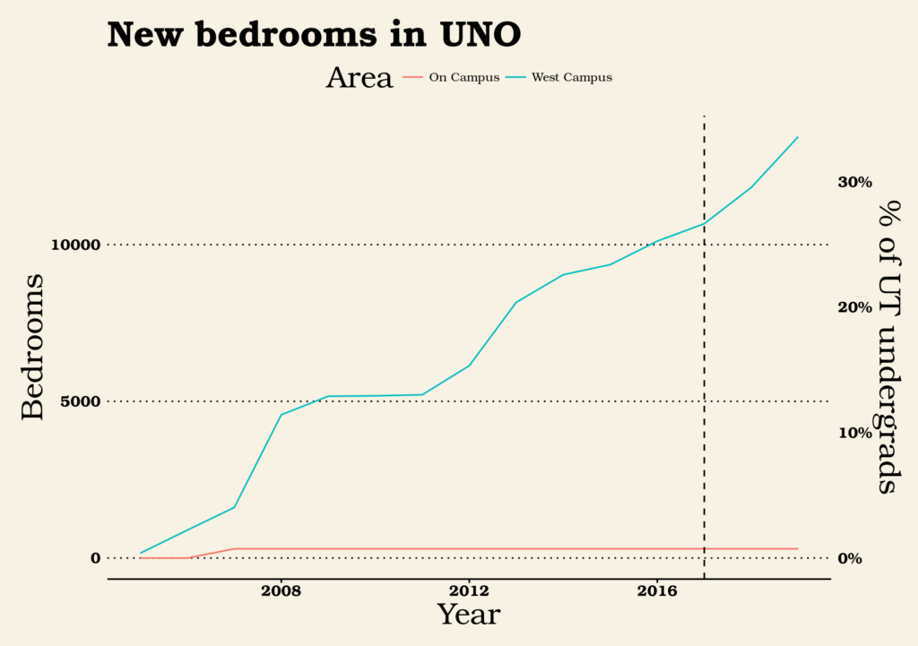
In this chart, I show two equivalent axes: bedrooms (on the left) or % of UT undergrads those bedrooms represent (on the right). I chose to use bedrooms rather than units because of my intuition that student housing is typically occupied by one person per bedroom, so a 4-bedroom unit really does house twice as many people as a 2-bedroom unit. (In other housing, a 4-bedroom unit may mean that one or more bedrooms are being used as a study or guest room.) The blue line shows the number of new bedrooms created in the UNO overlay, while the red line hugging the bottom shows the number of new bedrooms created by new dorms on the UT campus itself. Numbers after 2017 are projections based on city filings rather than completed units on the ground. At the rate UNO is growing, approximately half of UT undergrads will live in new units created under UNO by 2023.

A lot of investment

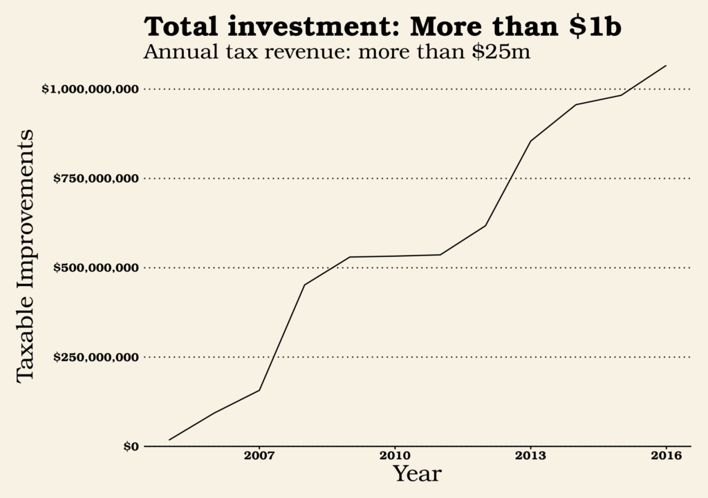
How much does it cost to build out a neighborhood? Using 2017 tax valuation, the UNO buildings alone (not counting the land they sit on) were valued at a bit more than a billion dollars. For comparison, Austin’s last affordable housing bond was for $65m and the capital costs of Austin’s proposed 2014 light rail bond was about $1.5 billion. Each year, the buildings in UNO contribute more than $25m in property tax revenues to the various local government taxing entities: the city of Austin, Travis County, Austin Independent School District, Austin Community College, and Central Health.

A lot of new income-restricted apartments

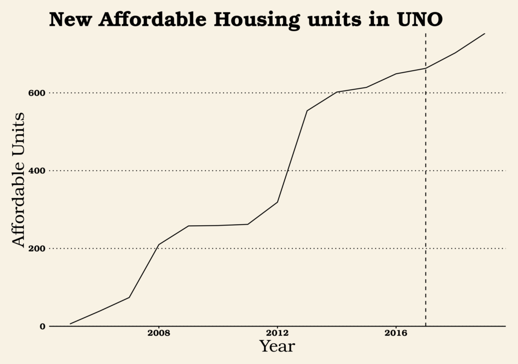
West Campus is home to one of the largest concentration of developments in Austin with apartments specifically for people below certain income levels. There are two reasons for this: 1) as part of the new rules for building apartments, developers are required to set aside a certain number of units for eligible people, and 2) there has been a lot of development in West Campus.

Part 2: How UNO has changed over time

Buildings are getting bigger

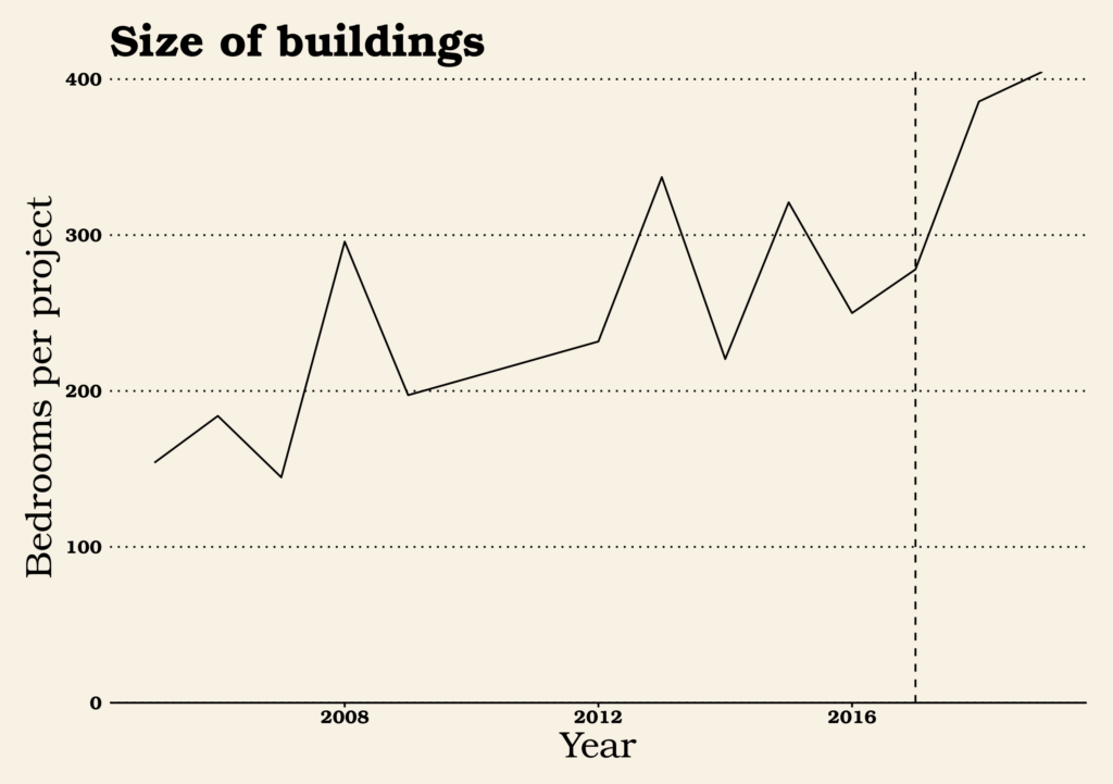
Buildings are getting bigger overall, as expressed by number of bedrooms per project. I’m not sure why this would be; perhaps easier-to-finance mid-rise buildings have proven the way for larger high-rise projects. Perhaps the most easy-to-build sites were in the lower height districts and investors are moving on to the more difficult-to-build sites in high-rise districts.

Parking by bedroom

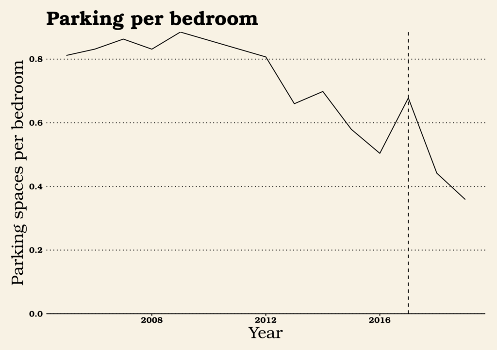
Over time, the number of parking units added per new bedroom built has dropped precipitously from a high of nearly 0.9 parking spaces per bedroom to 0.5 in 2016 and an anticipated 0.36 in 2019. Apparently, when we build places near other places, more people can get around without a car. There’s a number of ways these change might be explained:

  • Developers and financiers have become more comfortable with building less parking as earlier buildings saw less parking used than anticipated.
  • As more commercial amenities have moved into the neighborhood like the Fresh Plus grocery store, fewer students have needed cars.
  • Younger people more generally have lower preferences for having cars with them at school than they used to.
  • Developers have gotten better at managing city rules to find ways to avoid expensive required parking. (More on this later.)

Bedrooms per Unit

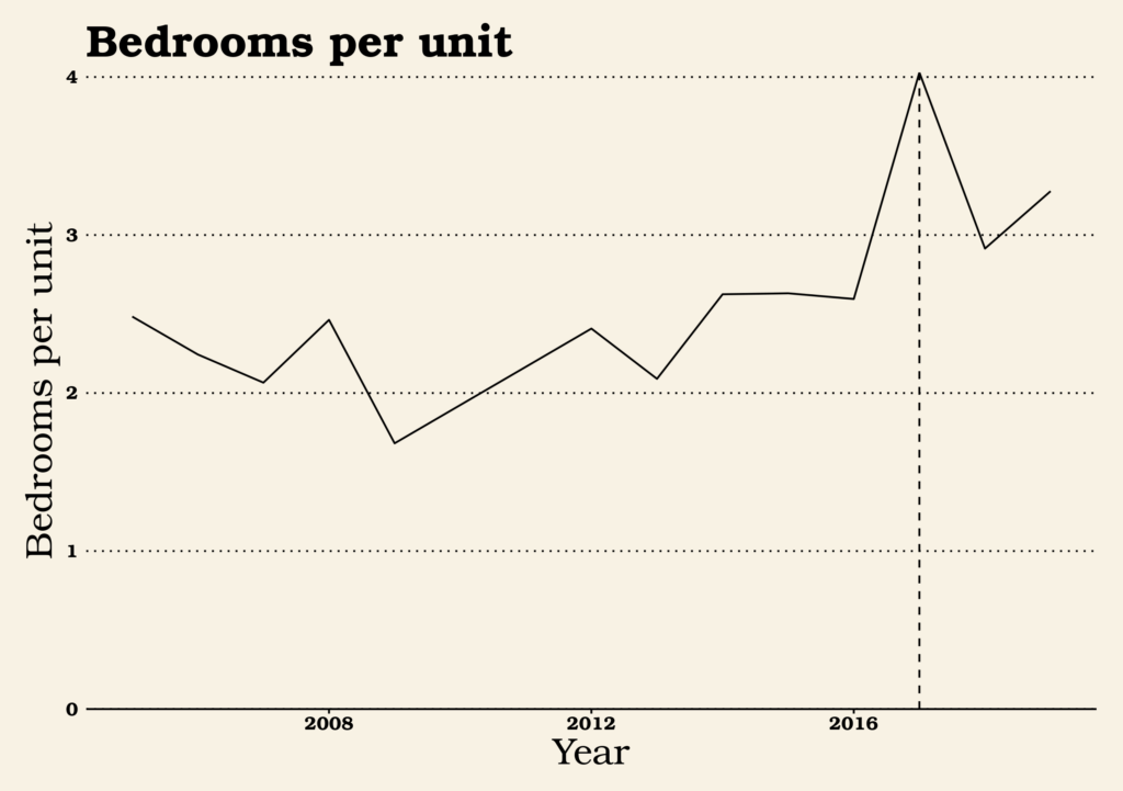
The number of bedrooms provided per unit is a major way that West Campus departs ways from the rest of Austin. Developers typically build studios and 1-bedroom apartments to accommodate the many 1- and 2-person households the city is adding. In West Campus, developers have always built more bedrooms per unit, probably because students are more willing to share a suite with unrelated roommates than many non-students. Of late, though, the  number of bedrooms per unit is going even higher. Why? I have a hunch.

Parking by Unit Size

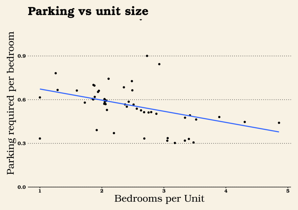
This is a trickier chart than the others. On the bottom axis, there’s bedrooms per unit. On the left axis, there’s parking spaces required (not built) per bedroom. The dots and the blue trend line both show that, generally speaking, the more bedrooms provided per unit, the fewer parking spaces a developer is required to build.

Based on the trend toward less parking per bedroom and more bedrooms per unit, my hunch is that developers have figured out that parking is not an amenity that enough students want or are willing to pay for to justify the fairly high costs of building it. So now they’re trying everything they can to avoid the expense of building unwanted parking garages, including build bigger suites for which they aren’t required to provide as much parking. If this is true, it’s another example of a remarkable property of zoning codes: they always have unintended consequences. Zoning code didn’t set out to decide how many college students should group together into a suite, but it might well have decided it nonetheless.

[Edit: A dissenting view comes in from friend-of-the-blog Tyler Stowell.  See below.]

Conclusions

This has been a fun romp through a little dataset. Let’s reiterate some of the conclusions I’ve drawn:

West Campus shows little signs of slowing down

There are sometimes worries that when a part of town allows denser housing, there will be a big bang as all the most likely sites get developed and the ones that remain all have special problems. If that’s the case with West Campus no effects are obvious. New sites come on to the market all the time and there are still surface parking lots or low-rise buildings that are prime targets for redevelopment. We could well see new West Campus buildings account for 50% or more of the undergrad population before long.

The city still requires too much parking

The trend we observed toward fewer and fewer parking spaces being built — and especially the trend toward weighting the unit mix toward parking-light high-bedroom units — tells me that developers are seeing little use and little market for their parking. With Bcycle rideshare taking off on top of the existing walking, biking, and bus routes, most students in West Campus just don’t want or need cars. Eliminating parking minimums would also allow developers to be more creative in other areas, providing different amenities or lower costs.

The city regulates way more private investment than it makes public investment

So far, rebuilding West Campus has been a $1B project, far dwarfing the amount of money the city has spent directly or indirectly on housing development. Most of the time, we don’t think of it as a single “project” because there is no one single coordinating entity controlling what buildings get built in what order. But it was created as a result of a city policy change. Even the smallest changes to city policy, in this case only affecting a single neighborhood, can end up affecting far more private investment than direct municipal spending affects.

[Note from friend-of-the-blog Tyler Stowell:] I’d disagree with one of your points though – my observation is that the higher bed/unit ratio isn’t a way around parking requirements, it’s a cost cutting measure. Bedrooms are cheap and pay rent. Kitchens and bathrooms are expensive and don’t pay rent. Diluting the cost of kitchens/baths over more beds equals higher profit for the developer. And this works in west campus for college students who might’ve lived in Jester last year. Not so much in other markets. The parking is always a target percentage of bedrooms and truly is market driven (eg. my last project the developer wanted to provide a space for 80% of bedrooms). Some projects take the full reduction allowed by UNO, but some go higher.

Can CapMetro CEO Randy Clarke hit the Project Connect softball out of the park?

Project Connect, the government group responsible for proposing big ideas for the future of Austin transit, has unveiled their latest vision (shown below). I haven’t dug into the details as much as I will over the coming months but from 10,000 feet, I’m impressed. Their analysis confirms that water is wet, the sky is blue, and the three corridors where light rail makes sense are Guadalupe/Lamar, East Riverside, and South Congress, with Guadalupe/Lamar being the very best. Additionally, the analysis identifies two more high-quality transit routes (South Lamar and Manor) where great bus service could work well and one medium-quality transit route (ACC Highland via UT campus and Red River) where pretty darn good bus service is possible. There’s also an interesting thought for a future connection to the Domain.

Although I haven’t done an extensive survey of transit advocates in Austin, most of the talk I’ve seen about this plan has been extremely psyched. This isn’t just one expensive but low-ridership rail route for the point of having rail, but a system of interlocking lines that make sense with one another. The plan may not be perfect but it does look very good.

So why mention Cap Metro CEO Randy Clarke?

Astute observers may have noted a difference between my description of the Project Connect system and the map they released: I referred to three lines as being designated for light rail, whereas the Project Connect map refers to them as being “high ridership and cost.”  Project Connect staff had mapped what mode (i.e. bus vs rail) makes sense for each corridor but CapMetro CEO Randy Clarke asked them to hold off on including it in their Phase Two report. Project Connect has set up Randy Clarke with a perfect softball pitch: come in to a new city and put a stamp on the most ambitious long-term plan to create a city with first-class transit. The question is: why is he not swinging?

Don’t gaslight us, Randy!

I’m still recovering from a bitter campaign on Austin’s last transit proposal, Proposition 1 in 2014. I rely on transit to get anywhere outside my immediate walking radius so it was extremely difficult to make my debut in local politics by opposing a major transit plan. But it was something I felt I had to do and to this day, I resent the fact that staff placed transit advocates in that position. It wasn’t just that most of the advocates had come to a different conclusion than the planners about route choices. I actually felt like through the course of the route selection process I was being gaslighted. I dug deeper into the 2014 route choice model than I ever wanted to. Every time I found a bizarre choice, I was told that no, the sky has always been red and it makes perfect sense to, say, assume students would be as likely to walk more than a mile from their home to a train station as they would be likely to walk half a mile. Or that it makes perfect sense to count potential homes as twice as important to ridership than actual existing homes.

When I look at this latest Project Connect map, I feel not only excitement for Austin’s future but a definite sense of relief and vindication for having argued that the sky was blue. Project Connect has confirmed that the non-professionals like myself who were skeptical of the 2014 process shared the same thought process with many professionals in the industry. That while some folks called myself and friends “transit trolls” and literally told us to “shut up” and listen to the experts, I wasn’t being naive to question, say, whether tunneling underneath the Hancock Center was really the best use of scarce transit funds. (It was then and remains a bad idea.) The conclusions that the professionals have drawn this time around are completely in line with the conclusions the amateur advocates drew last time and a fairly sharp repudiation of the 2014 proposal. But this sense of relief isn’t unlimited. The longer that any part of the Project Connect effort staff or leadership go without being willing to state obvious facts, the more that I worry that this effort, like the last one, will be derailed by bad choices.

Are autonomous vehicles the answer?

So reading Randy Clarke say things like: “We are not that far along from having maybe a (bus rapid transit) type of system that is autonomous, connected and electric that in a lot of ways may meet a lot of the desires and outcomes that modern-day (light rail transit) delivers because you may be able to connect two, three or four vehicles and separate them in a much different way, similar to how light rail system works today but with a lot less cost structure,” I get nervous.

Of course, driverless vehicles that connect multiple cars and carry a lot of people have existed for decades. Here’s one in Vancouver:

And if it’s true that radical new technologies change the cost equation at some point in the future then by all means nobody thinks we should ignore that. But for the sake of the collective sanity and confidence of Austin transportation advocates, Project Connect should come out and say “Barring anything paradigm-changing, these three routes are ripe for rail and the others should use some combination of enhanced bus measures.”