Does transportation serve people or do people serve transportation?

No big city has solved either of two problems: making car traffic flow smoothly or making parking simple and cheap. The issue isn’t that governments in every city are bad, though sometimes they are, or that traffic engineers didn’t anticipate the future, though sometimes they didn’t, or that drivers drive too aggressively, though sometimes they do. The issue is that these problems are impossible to solve due to basic geometry. You can fit more people close together than you can fit cars close together. In a small town, you can fit all the people and the cars together without much difficulty. But as a city grows larger, it’s easier to accommodate people, which are relatively small, compared to cars, which are relatively large.

There are a million ways to think about this that all come to the same conclusion. Caleb Pritchard has pointed out that there is more space downtown devoted to parking cars in downtown Austin than there is space in all of downtown (some of the parking spaces, of course, are stacked in multi-level garages, so the math works):

New office buildings in Austin devote as much space to storing cars as they do to storing people.

This is ugly and wasteful and terrible for the environment and extraordinarily expensive. It requires people to spend a long time and sometimes a lot of money circling up floors or circling city streets to find parking spaces and people hate the process with a fiery passion. People’s (un)willingness to circle up floors to park is the binding factor limiting the size and creativity of downtown office buildings in Austin. Car parking is the reason our office buildings are shorter than our residential towers — illustrated nicely by how the Sullivan’s Tower got shorter when it was converted from apartments to office. Car parking is also the reason our office towers are shorter than office buildings in less car-oriented cities like, say, New York or Houston. But despite all that, it kind of works. Every work day, 100,000 people find a place to store 2,000 lbs of metal within a square mile of land, so that they can be close enough together to hold a meeting in the conference room or walk to the courthouse or the state house or the post office or city hall or each other’s offices or any other places they need to go as part of their work day.

As bad as the parking situation can get, it’s good news compared to figuring out the logistics of moving them around the city. We can make many more multilevel parking garages in downtown Austin before we run out of space, but stacking cars on top of one another when they’re driving (by building tunnels or elevated streets) is prohibitively expensive for more than a few major highways. Even then, the best you can hope for is two or maybe three levels that people hate to drive on, look at, or live near. You can widen streets to handle more cars, but the more space you use for streets, the less space you have for the places people are using those streets to go.

Another option is to spread buildings out. Instead of a huge chunk of people coming together to work downtown, make many different employment nodes around the city. This can work, to some degree. But the reasons people needed to be in close proximity to one another don’t go away, so the cure is often worse than the problem. Instead of finding a way to get people who need to be in proximity with one another into a small walkable area, you require them to drive half an hour to get to any meeting they have, creating even more traffic and making things even worse!

There’s simply no solution that allows people to get wherever they want in a big city in a car without facing traffic along the way. Implicitly, when we develop new buildings, our development rules recognize this fact. New buildings are required to perform a “Traffic Impact Analysis” which uses arcane, inaccurate, and context-free rules to model how many times per day somebody will arrive at or leave a building, depending on what kind of things people do inside the building. Rules which require a TIA often limit the number of so-called “trips generated” for a particular development.

The basic idea behind trip generation limits is the understanding that big cities and cars are fundamentally incompatible. Rather than limiting the use of cars, limits on “trips generated” are a vain attempt to limit a city from growing too large to outgrow the usefulness of cars. The reason why this attempt is in vain should be apparent: trips aren’t generated by buildings, but by needs. Sprawling trips out over a bigger area merely forces people to drive even further, creating even more traffic.

Of course, just because cars and big cities have fundamental conflicts doesn’t mean cities can’t continue to outgrow the constraints of car-oriented development. There are countless solutions: buses, trains, bikes, scooters, sidewalks, dollar vans, etc. The details of each solution vary but the overarching idea is very similar: 1) make trips shorter so people don’t need to travel as far to get to the places they want and need to go, and 2) fit people closer together while they’re making trips to make more efficient use of each street.

There have been some positive ideas on reforming TIAs to use these solutions, California being the best example in the US. But I’d like to propose a different way of thinking what a TIA could be. Instead of assuming cities are tied to cars only and then limiting developments to the constraints that cars have, we could start with the development we want and then require that this developments accommodate whatever transportation system is necessary to complement it. Instead of trying and failing to scale cars to a level that they simply aren’t capable of handling, we find the transportation system that is actually capable of handling the development.

For example, if a developer proposes a development whose size or density tips past the point where most trips can be comfortably done with cars, she would be responsible for providing street designs that include different ways of getting around: bike lanes and bike corrals, or designated places to store dockless scooters, or proximity to a transit line.

There is a sense in which we do this already. Austin’s land development code, like many others, requires infrastructure for cars (mostly parking) but allows developers to provide less of it if they provide alternative transportation infrastructure (e.g. parking spaces designated for shared cars like Car2Go, showers for bicyclists). But these efforts are piecemeal and complicated. All too often, TIAs are wielded as weapons to prevent homes and offices, when instead, we could make them a tool to make any development work.

6 things to like in California’s proposed transit housing law, illustrated by surfing

On January 4, California felt two earthquakes. The first was a conventional and thankfully weak earthquake in Berkeley:

The second was a political earthquake, emanating from across the bay in San Francisco:

So, here are six things to like about the transit-oriented development bill that’s making waves in state politics:

1 It acknowledges the state has an interest in land use

Many decisions are better made by cities than states. Where will the next branch library go? Should this park have a splash pad or a lawn? But some problems are too big for one city alone, like intercity transportation. If Austin and San Antonio decide to be connected by a train, Buda, Kyle, San Marcos, or New Braunfels should have input (as the train would go through these cities), but they shouldn’t be given a flat veto. It is up to the state government to help manage this process so that local interests in one city don’t hurt local interests everywhere else.

In California and some other states, housing and land use have become problems with statewide and national implications. Housing prices aren’t just high in San Francisco or Los Angeles or even Berkeley; people unable to find housing in those cities are spilling over to suburbs and exurbs all across the state. Whole companies are looking to other states to set up offices because their workers can’t afford California rents. The greenhouse gases from long commutes affect every person on the planet. When a problem is widespread, the solution needs to be widespread too; cities rules by local interests just doesn’t cut it.

When one city’s rules starts to affect not just themselves but others, it can be time for the state to set in and make rules.

2 It creates fair and impartial rules

Laws made at the local level can take into account local context better than statewide rules can be. But laws made at the state level can better take into account the statewide context. In a drought, we need fair rules so that everybody does their part to conserve water and everybody has access to the water they need. In a statewide housing drought, we need fair rules so that everybody does their part to build housing.

Everybody has to play by the same rules.

3 It forges a link between transit and density

In the sphere of YIMBY and placemaking, the problem in California is a very YIMBYish problem: there aren’t enough homes to go around for all the people who want to live in California’s cities. But the solution that Wiener proposes isn’t just focused on getting people into homes anywhere. By proposing rules for allowing more homes near transit, it creates the chance for cities to use this as an opportunity to make great places for the future, where high-capacity transportation solutions are matched with high-capacity housing solutions.

Transit is great because everybody can ride together.

4 It acknowledges how parking rules can hurt housing

One type of land use rule that’s particularly pernicious is the minimum parking regulation. These rules not only incentivize car use by forcing everybody to pay the price of car storage whether they drive or not, they also cut into the budget (both financially and physically) of new housing. This legislation will stop cities from using these pernicious rules near transit stops and opens the possibility for people to find new ways to live cheaper while using less parking.

Not everywhere is perfect for parking.

5 It helps bridge the gap between people and jobs

The problems of California’s cities aren’t their problems alone. Vast swathes of the state are home to unique industries, from Silicon Valley’s tech economy to Hollywood’s movie industry. Sure, tech jobs exists outside Silicon Valley and movies are filmed all over the world. But place has, if anything, grown more important over the last decades, not less. Young workers looking to break into an industry would do well to show up where the jobs are, and new companies looking to start up would do well to show up where the workers are. Today, though, many people are shut out of these engines of prosperity because they can’t afford to live in Palo Alto, San Francisco, or Los Angeles while they lean the trade. Who knows what great technology or film talent we may cherish tomorrow if only we make room for them today?

Some folks in California’s economy find good jobs and places to live while others are simply couch surfing.

6 It might just save humanity

With the United States federal government oriented away from action against climate change, individual states badly need to step up their game. While trying not to overstate the importance of this bill, the fate of the entire human race might depends on our ability to transition the United States and our high-emission society into one in which we can get around more efficiently.

If we don’t address climate change, there’s a wave heading our way that California — and humanity — might not be able to ride out.

So congratulations to Senator Scott Wiener! You brought a proposal that deals with the scale of the problems your state and this country are experiencing, and you may have changed the conversation on housing for good.

Words by Dan Keshet. Gif selection by Susan Somers.

Five Things to Like and Five to Improve for the North Shoal Creek Neighborhood Plan

Susan Somers is a north Austin resident near the North Shoal Creek area, President of urbanist organization AURA, and the genius gif editor who made this blog’s most famous piece pounce.

The city recently released a draft version of the North Shoal Creek Neighborhood Plan. North Shoal Creek is on the far edge of what you might consider north central Austin – bounded by Anderson Lane to the south, Highway 183 to the north, Mopac Boulevard to the west, and Burnet Road to the east. The plan is set to be the first new neighborhood plan in several years and City planning staff seem to have billed it as a kinder, gentler neighborhood plan: one that would try to fulfill the goals of Imagine Austin and identify new opportunities for growth. As such, the draft plan may give us a decent sense of what small area planning would look like if we continue churning out neighborhood plans in the CodeNEXT era.

How does the draft North Shoal Creek plan stack up?

Outline of North Shoal Creek, via the draft plan.

Five things we like

  • The plan acknowledges the reality that apartments are more affordable and single family homes are not. The plan repeatedly points out that the apartments and multifamily condominiums in the neighborhood are more affordable that the single family homes. What’s more, “Apartments and condominiums in North Shoal Creek provide more affordable options relative to much of Austin, while single-family homes are less affordable than the citywide average.” It also acknowledges that the majority of people in the planning area live not in the single family homes of the “Residential Core,” but in apartments along the edges of the neighborhood. Furthermore, it points out that the neighborhood’s residents are aging, and young families are being priced out.
  • The plan prioritizes walkability. Almost half the “needs” and “values” identified by the community involved walkability in some way. The plan calls for new sidewalks and trails, better access to transit stops, and improved safety for schoolchildren walking to Pillow Elementary. It even contemplates innovative ideas such as opening up a pedestrian trail to access Anderson Lane businesses or allowing the community better access to Shoal Creek.

    Hundreds of people live here, but this is not a place that invites walking. Image via Google Maps.
  • The plan allows homes on the neighborhood corridors. The plan acknowledges that retail, particularly along Burnet Road, is dying. It allows for mixed-use development including apartment homes to be built along Burnet Road and Anderson Lane, the neighborhood’s major corridors. It also acknowledges that transit access is a very important reason to allow these homes to be built, and that apartment density should be clustered near transit. While allowing apartments on transit corridors may seem obvious, North Shoal Creek has fought apartment homes in the past, so this is a promising development.
  • The plan supports granny flats (aka “accessory dwelling units”). The plan seems to support allowing homeowners to build granny flats throughout the single family section of the neighborhood. Adding another home to a lot is an easy, almost invisible way to add more housing!
  • The plan envisions an innovative “Buell District.” Buell Avenue is currently dotted with light industrial development like self-storage facilities and auto-repair shops. The plan envisions change along Buell Avenue, including special zoning opportunities like townhouses, small apartments, and live-work spaces that would allow a greater variety of housing into the neighborhood.

Five things to improve

  • Choose some side streets for rowhouses. Other than on Buell Avenue, the plan does not call for allowing missing middle housing types like rowhouses on any side streets. We’ve previously argued rowhouses are an underappreciated and underused housing form in Austin, and CodeNEXT should allow more of them. But over and over again, our planning processes shy away from this awesome type of home. There are plenty of larger neighborhood streets in North Shoal Creek that would be appropriate for rowhouses. The plan leaves the impression that the only reason townhouses would be allowed on Buell is that the neighborhood likes the current light industrial businesses even less than they like rowhouses.

    Rowhouses are a residential type of building and, as such, they belong every bit as much in residential-only areas as areas of mixed use.
  • Multiplexes or small apartments on corner lots. Similarly, other missing middle housing types like multiplexes, small apartments, or cottage courts, are not placed in the “Residential Core,” even on large corner lots. Large corner lots are the perfect place to allow this kind of missing middle.

    This fourplex is one of the last standing of a formerly common missing middle housing type in residential Austin.
  • Sanctity of the “Residential Core.” Let’s talk more about that “Residential Core” phrase. As we note above, the plan acknowledges that the majority of residents live not in the interior of the neighborhood in single family homes, but in apartments on the edges of the neighborhood. Thus, calling the single family section of the neighborhood residential as compared to the corridors is a kind of double speak. Literally, more residents live outside the area termed “residential” in this plan! Based on the plan’s constraints, that pattern will become even more pronounced! Why does this terminology matter? Many other aspects of the plan focus strictly on the “Residential Core.” Three of the six bullet points regarding the goals of the Neighborhood Transition area focus not on making the zone great for its residents but on how not to encroach on the privacy of single family homes. The poorer majority residents are treated as interlopers on the richer minority. In fact, it’s not even clear that the existing apartments in the Neighborhood Transition lots would fit the constraints of the plan.
  • Vision for connectivity/reconnecting streets. Residents in North Shoal Creek have asked for a more walkable neighborhood and for better access to transit stops. One way to make this area, designed with meandering streets and suburban cul-de-sacs, more walkable would be to designate opportunities to acquire lots and reconnect streets separating people from one another. While the plan considers this for connecting homes to retail via urban trails, there are no such connections proposed in the “Residential Core.”

    Google Maps recommends a 17 minute walk along a freeway to walk between these backyard neighbors.
  • Tying desired neighborhood amenities (sidewalks, parks) to opportunities for density. There are many ambitious, desirable aspects of the plan that are unfunded mandates. These unfunded plans include building out the sidewalk network, adding urban trails, developing more parkland, and creating the Shoal Creek trail. The plan acknowledges the challenges of getting funding to make these a reality. But other neighborhoods where these improvements have actually taken place (like Bizarro Austin) have done more than make a wishlist and hope. They created incentives for redevelopment to happen and required developers to fund improvements to the public sphere as part of that redevelopment.

In some ways, the North Shoal Creek draft plan lives up to its kinder, gentler billing. It recognizes the real problems the neighborhood has: from families being priced out to unwalkability impinging on quality of life. The plan promotes the two main fixes we’ve also seen coming out of the latest draft of CodeNEXT: accessory dwelling units and apartment homes on transit corridors. Let us acknowledge that many of Austin’s older neighborhood plans don’t go even this far. However, to truly confront the problems the plan identifies, broader changes are needed, including in areas where the minority of neighborhood residents live. By opening up to a bit more change, some of the truly visionary elements of the plan could be funded and constructed.

Real-time bus data can improve effective frequencies

In February, Capital Metro expanded the reach of real-time bus data from the 801 and 803 routes to the entire fleet. There have been a few pieces about the promise of real-time data: the piece of mind of knowing your bus is actually on its way, the ability to save wait time by only heading out to your stop at the last minute, the promise of real-time data to evaluate system performance. I’d like to add one more: improving practical frequencies.

As long-time readers know, one of my pet peeves is buses that run in the same direction, but pick up at slightly different locations. Two bus routes that each run 2x / hour and run together for some length could become one combined route running 4x / hour along that length if they picked up at the same location. In Austin, this is the case for the central transit corridor from downtown to UT / West Campus along the 1/3/5/19/801/803 bus routes.

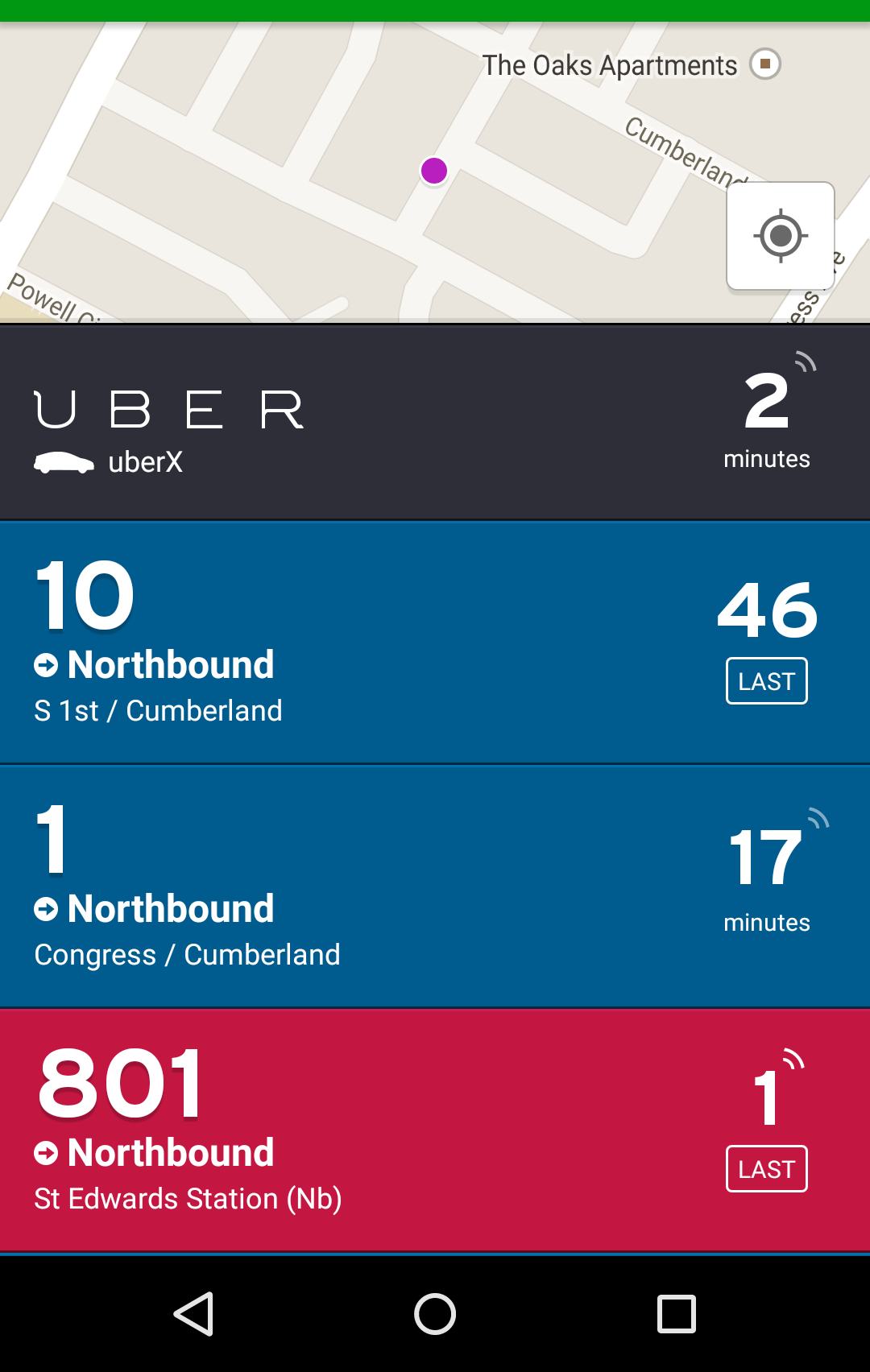
Downtown, the problem I complained about in the linked piece has been resolved; almost all north-south bus routes through downtown are now running on the Guadalupe / Lavaca transit priority lanes. However, during SXSW, as I stayed in a short-term rental in between South Congress and South 1st, I had a less extreme version of the same effect. My location was halfway between the South 1st corridor, where the #10 bus ran and the South Congress corridor, where the #1 and #801 buses ran. In the pre-real-time data days, this would have meant that I would have had to choose between waiting for the 10, waiting for the 1, or waiting for the 801, all of which pick up at different stops.

With real-time data, I could just look at my free Transit app and see which bus was approaching next:

Transit App Screenshot

During morning rush hour from my rental to downtown, there were five buses per hour on the 801, two buses per hour on the 10, and two buses per hour on the 1. Prior to real time data, that equals five buses per hour, as I would have had to choose which stop I was going to wait at and would’ve chosen the one with the most buses. With the advent of real-time data, that equaled 9 buses per hour, as I could choose which stop actually had the next arriving bus. Obviously, this only applies in some locations. But where it does, it’s a major improvement!

Playing around with a gridded transit system

Yesterday, I was exposed to a new tool that came out of Code For America: TransitMix.  It’s intended as a tool for allowing lay people (and eventually professionals) to draw up transit systems.   The map that I drew up (ideas you like are from Brad Absalom; ideas you dislike are from me)is a very preliminary interpretation of how ideas gleaned from reading posts on Jarrett Walker’s blog about a grid-based, transfer-happy system could work in Austin.  For this post, I will call the system I drew up Reimagined in the spirit of Houston’s System Reimagining (on which Walker consulted). For speed, I didn’t take on MetroExpress (i.e. 983, 985, 990), the Flyers (e.g. 103, 142, 171), or the UT Shuttles (e.g. FA, WC, LA).  I also ignored off-peak times for the same reason.

I constrained myself to reality in a few major ways: 1) using the same number of peak-hour buses that I calculated Cap Metro to use within MetroBus / MetroRapid (136 buses).  This gives a rough idea that the new system has similar total expected costs.  2) I attempted to keep coverage for as many locations currently served by a bus as I could, 3) I did my best to give average run speeds based on real Capital Metro runtimes along segments, including rest times for driver breaks.

I only drew this up for Devil’s Advocate purposes at this time–I’m intrigued by it enough to throw a Saturday afternoon into making it, but I’m sure there are issues I haven’t thought about.  It’s a very first cut, just an attempt to follow the principles and see where it leads.

Continue reading

Proposed Fare Changes

Capital Metro is currently going through an analysis of their proposed fare changes. These are the questions I intend to ask about the proposals at the Open Meeting on Wednesday:

1. What, if any, are the projected changes in costs associated with each of the proposals?

2. If there are no projected changes in cost, by what analysis do you consider it worthwhile to eliminate 117,000 MetroAccess rides to gain a negligible $9,000? If there are projected changes in cost, how do you expect the public to judge this proposal without providing the data?

3. Is the additional revenue and lost ridership for changing premium service to $1.50 measured against the current baseline or the baseline of a change to $1.25?

4. What would the revenue and ridership numbers be different if you had adjusted the MetroBus fares to $1.10 or $1.50? Presenting only the selected numbers gives us little room to judge the proposal by.

5. How will day passes work when transferring between premium and base service?

6. Will different fares between MetroBus and MetroRapid cause difficulty in advanced payment facilities, such as the promised smartphone app to prepay MetroRapid? If passengers opt to pay cash, will this slow MetroRapid down?

7. You dismiss collecting payment for parking as too difficult logistically, yet 100s of private operators consistently collect parking payments for much smaller lots than Capital Metro operates. If you don’t believe Capital Metro is capable of operating as well as them, did you consider outsourcing the job to one of them?