What makes for awesome public transportation

I don’t drive. When I arrived in Austin, I learned this was a hard city to get around in without driving but I didn’t know exactly why. This search to understand what makes Austin so hard to get around without a car is what got me all mixed up in this world of blogging and advocacy. I still don’t have all the answers today but I’d like to share some of what I’ve learned on one specific topic: what makes for great public transportation.

Public Transportation Needs to Go to Great Places

Public Transportation needs to go where lots and lots of people need to go

Not every one needs to go to the same place. So the best public transportation doesn’t go absolutely everywhere, but it does go to places many people need to go: places where oodles of people live nearby or oodles of people work or shop or visit or ideally places where oodles of people do all of these things. In different places and social circles, public transportation has a reputation as being only for poor people or only for rich people, but  the best public transportation isn’t limited to only poorer areas or richer areas.

The Polar Express winds through large buildings on either side. via GIPHY

Public transportation needs to go to walkable places

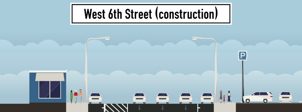
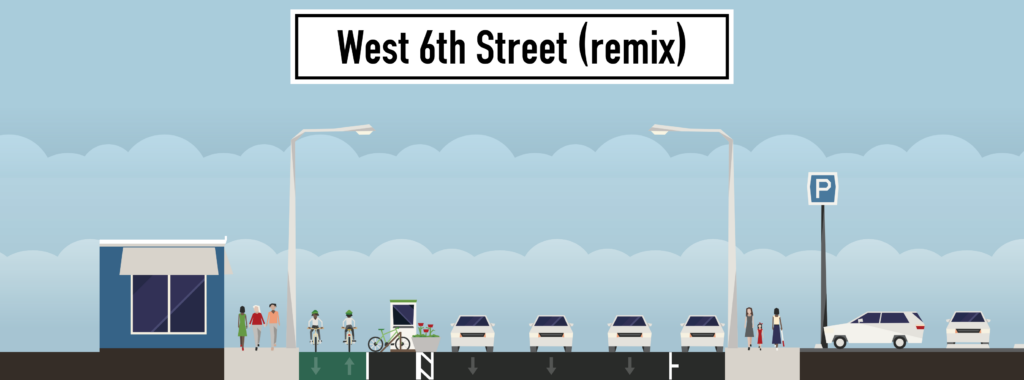
Great transit isn’t like taking a taxi. You can’t expect it to carry you straight to the door of where you want to go. This means that when you get to your stop, you have to have a safe, comfortable, accessible way of walking (or using your wheelchair or scooting or biking) the rest of the way to your final destination. Bonus points if there’s easy bike or scooter shares right at the transit stop for you to take the rest of the way. Extra bonus points if you can pay for both with the same fare payment system. Connecting transit to cars by putting parking lots at transit stops or transit stops next to a highway usually makes transit worse not better. Cars take up a lot of room, they’re loud and emit noxious gases and they hurt a lot if they hit you.

Public transportation needs sensible stop spacing

The best stop spacing for a route depends on the rest of the services offered. For example, trains running underground will be better off with larger stop spacing, for the most part, than a bus running in mixed traffic. Walking long distances to a station is more acceptable when the payoff is a fast and reliable ride once you get there!

Public Transportation Needs to Get You There Quickly and Reliably

Straightforward lines

Great public transportation connects great places in logical and straightforward ways. A single bus line could hit every great place in a city but if it takes you hours to wind through the city, that’s not very useful.

Exclusive lanes

Great public transportation doesn’t get caught in traffic. A vehicle filled with 30, 130, or 300 people should never be made to wait behind lines of vehicles with 1 or 2 people in them. That means it needs its own transit-exclusive lanes that individual vehicles can’t use. Transit-priority lanes (e.g. lanes that non-transit vehicles can only use if they’re turning) are better than buses or trains running in normal traffic but still way worse than transit-exclusive lanes.

Grade separation

Getting stuck behind a car isn’t the only way to slow a bus or train down; you can also get stuck waiting for cars to clear an intersection. That’s why the best public transportation runs either below-ground or above-ground. If public transportation vehicles and private cars are both running on the ground, a second-best solution is to give transit vehicles “signal priority” — the ability to turn lights in front of them green before they get to the intersection.

Frequent service

Time waiting for the ride to start is time wasted. Looking at timetables is an annoying hassle. The best service is the one you can just show up for, secure in the knowledge that there’s a vehicle coming for you soon.

Good communication

Having said that, it’s still useful to know when the next vehicle is coming. Signs in the station, apps, and APIs for third-party apps should all have real-time updates on when the next vehicle is coming through.

Fast boarding

Transit shouldn’t take forever to load and unload. One way to speed up boarding is to provide platforms, so that stepping (or even more so, rolling your wheelchair) on to and off of the bus or train can happen quickly. Another way to speed things up is to have people pay while they wait at the stop or station, rather than as they board. This can be done many different ways, like turnstiles that control access to a station or ticket-vending machines providing receipts that randomly get checked. Imagine how much less useful an airport tram would be if every passenger had to board one at a time and pay at the front!

Transit should be safe and comfortable

Clean, well-lit stations or stops with comfortable places to sit and shelter from the elements

This is almost too obvious to mention yet many transit agencies don’t even provide the bare minimum. At the end of a long work day, the last thing anybody wants to do is wait in the rain or the blistering heat or sometimes even stand up longer than they have to.
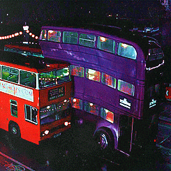
Comfortable ride

Comfort doesn’t stop once you get on the vehicle. One big difference-maker is how smooth the ride is. Trains generally offer a smoother ride than buses, which depend more on both the quality of the vehicle and the quality of the road. Another difference-maker is engine noise. In this aspect, electric vehicles are better than diesel ones, which again is an advantage more trains have over most buses.

Some bus rides are magical in all the wrong ways.

Public transportation should be cost effective

Almost every aspect described above costs something. Building shelters and platforms is more expensive than putting up bus stop signs. Ticket vending machines cost money to install and operate. Building subways is more expensive than running trains at street level. The art of making good transit is figuring out which of the items are essential for the service you’re running and which can be sacrificed. But there are also some more general principles toward keeping transit cost-effective.

Vehicles should have enough capacity to handle ridership

While there’s no sense deliberately running an overly large vehicle, almost all of the operations costs of running a bus is paying the driver. Running an empty bus costs a similar amount of money whether it’s a large bus or a small bus. Small buses is everybody’s favorite naive solution to saving money on transit, but often the extra operations costs of maintaining more types of vehicles actually makes this more expensive. But costs can really pile up when your vehicles aren’t large enough. Running 30 vehicles an hour with 40 passengers per vehicle is much more expensive than running 10 vehicles per hour with 120 passengers per vehicle. Classically, this has been one of the key tradeoffs of buses vs trains. Trains cost much more to install but their greater capacity per operator can yield lower recurring costs for high-ridership lines.

Three-month returns for CapRemap look very positive and what is happening to the UT shuttle?

A few months ago, Austin revamped its bus system, making a sweep of changes to routes known as CapRemap. The new system made a number of bus routes run more often, at the expense of longer walks to some bus stops, more transfers required, and some infrequently used routes being rerouted altogether. How has it been going? CapMetro employees say that a thorough analysis will require at least six months of data but I decided to take a sneak peek because we’re impatient and because I want a chance to gain some context about what CapMetro is, does, and how it got to here.

So let’s start! Early returns look positive. Very positive. Each line in this chart represents one year. 2014 only has one data point (December), so it doesn’t get a full line; just a single dot. And of course, I only have data through August for 2018.

To assess CapRemap, look at the purple 2018 line. For the first five months of 2018 (pre-Remap), it hugged the bottom. CapMetro carried fewer riders in January 2018 than January 2017, 2016, or 2015. Same for Februrary, March, and April. Almost the same for May. Starting in June, when CapRemap went into effect, CapMetro mostly reversed the trend, carrying more riders in each month in 2018 than in the previous few years. There are good reasons to not celebrate yet. June, July, and August are low-ridership months for CapMetro, so CapRemap hasn’t been tested in the busy season.

So let’s look a little bit harder at some background information, so we know what to look for as we continue to evaluate CapRemap’s performance in upcoming months.

Some things that jump out to me:

1. CapMetro Ridership is highly seasonal!  In addition to the summer lull discussed above, there’s a December lull (probably, again, because students and others take time off from work). There are also spikes in March and October, the two major festival seasons.

2. Until Cap Remap, ridership has been trending down each year. The highest ridership December was in 2014, with each successive December having lower ridership. 2015 was the highest ridership complete year, with 2016 and 2017 far behind. Before Cap Remap, 2018 was the lowest ridership of the lot. Cap Remap may have reversed this trend, but three months may not be enough to tell.

Let’s break these numbers down another way. Instead of breaking out years by month, let’s break them out by what type of service people rode: bus (local, express, or rapid), UT shuttle, train (MetroRail), Special Event, or paratransit (MetroAccess). This chart only shows the three years I have complete information on:

What do we learn?

  1. CapMetro ridership is overwhelmingly riding buses. The non-bus services like MetroRail and MetroAccess are vital services to the people who use them (MetroAccess especially), but to the extent CapMetro has a systemic effect, it’s overwhelmingly through providing buses.
  2. UT shuttle Ridership is dropping hard.

Let’s filter out the non-UT buses so we can see the rest of the categories better.

Again, the major plot point here is that UT shuttle ridership is plummeting. I’ve heard four theories why:

  1. Students are moving from bus-centric places like Riverside and Far West to walkable, bikeable, scooterable West Campus.
  2. Service cuts! Most routes have been either eliminated, combined, or had their frequency cut.
  3. More indirect service. As part of UT’s emphasis on making the core campus less of a place for motorized vehicles, UT shut down Speedway to cars and buses, making many of UT’s shuttle routes slower and less direct.
  4. UT shuttles used to be hop-on, hop-off. Today, they require UT students to swipe their ID and non-UT students to pay. This slows buses down and makes them less convenient.

How much do each of these hypotheses explain the ridership drop, if at all? That’s beyond the scope of this blog post. But just to confirm that this is an ongoing trend, here’s a picture of ridership of the UT shuttle on its own:

s

Yup, 2018 has continued that trend. Even the August number’s relative resurgence is probably more of a blip than a comeback, as August 2018 had more shuttle service days than 2017. Okay, we’ve looked at shuttle ridership enough. What happens if we look at total ridership again, but this time we look at all ridership except UT shuttles?

This changes things! 2017 goes from being the second-worst year to one of the best. Comparing this chart with the first, we can see the majority of CapMetro’s recent ridership losses have been from the UT shuttle. There’s a similar story to show regarding special event (mostly festival) service, which has also been declining in the last few years.

There are different ways of looking at this. On the one hand, we can say that CapMetro has actually been far more stable than some people (myself included) have given it credit for over the last few years. While nobody should feel satisfied with Austin’s levels of transit ridership, most classes of passengers aren’t leaving bus service even in drips and drabs.

On the other hand, UT students should be some of the easiest students to serve! They have less money to drive cars, they pay literally nothing for each bus ride they take (UT pays CapMetro a lump sum), they live in dense neighborhoods and travel to dense job / academic centers. CapMetro and UT have made some changes to this service over the last few years and ridership has dropped sharply! Did these changes cause the ridership drop? Were they worth it? If ridership is changing because more and more students live in West Campus, is it not time to look at improving service in West Campus? These questions haven’t got nearly the public hearing that they ought to have considering how dramatically UT shuttle service has declined.

I hope to make these charts a regular feature as new data is released. I will update some of the core charts above, enhance some of them with some more nuanced analytical techniques, as well as supplementing them with new charts to explain any interesting features we see in the data. Are there questions you’d like to see answered? What do you see in today’s charts? Let us know in the comments!

9/26 Update!

I have added some charts but it didn’t seem worth a new post.

[Editor’s note: these slides got lost in a server move. 🙁 ]

Something jumps out here! Sunday ridership is way, way up since CapRemap! This isn’t surprising as CapRemap increased Sunday frequencies. When the bus runs more often, people ride it more.

Finally, I’ve put together a bit of a more abstract chart. Two reasons why the other charts bounce up and down from month to month and year to year is that each month has a different number of days in it, and then even beyond that, each month has a different number of weekdays and weekends in it from year to year, depending on where it falls on the calendar. So I’ve created a notion of a composite month, which always contains 30 days, and which 1/7 of the days are always Sundays. This leads to a chart in which, instead of seeing ebbs and flows of which month has more weekdays in it from year-to-year, the ebbs and flows of ridership are based more strictly on how many people chose to ride the bus.

Nothing earthshaking here but that’s kind of the point. It’s smoothed out some of the jaggedness caused by February only having 28 days, or an August that has fewer weekdays than normal.

How West 6th Was Accidentally Fixed for the Age of Scooters (and How to Keep it Fixed)

There’s a new development on West 6th Street downtown. A six-story hotel going by the name “Canopy By Hilton” is being built next to Star Bar, between Nueces and Rio Grande (details at Towers). Space being rather constrained next to the hotel site, the developers have rented space to stage demolition and construction on the street itself, temporarily narrowing 6th Street:

Here’s what 6th Street looked like pre-construction from the perspective of the Google Maps street view car:

Let’s take that and simplify it a little in StreetMix:

Now, let’s look at what it looks like today:

sdr

Let’s simplify that in StreetMix again:

A funny thing happened on my walk home recently. I noticed that there were no cars parked in the parking spots on the left hand side of this picture and a number of people were using it to scoot in. The blocked-off lane was functioning as a buffer between the scooters and car traffic, thus creating a temporary protected lane.

If the city kept this configuration but made it slightly more permanent, here’s what it might look like in StreetMix:

I’ve replaced the car parking on the left with a two-way bike/scooter lane and updated the buffer so that people can use it to park scooters. Also, I threw in some potted plants as buffers to discourage people from using the buffer, by accident or impatience. The buffered area could not only fit scooter and bike parking, but it could do so and still leave room for a few taxi/Lyft pullouts. Is this the ideal configuration of West 6th? No; I definitely think a professional street designer could do better. But it shows how even a very low-dollar intervention could simultaneously remove some of the many annoying and at times dangerous conflicts on downtown streets:

  • Conflicts between people riding scooters and people driving cars
  • Conflicts between people riding scooters and people walking on sidewalks
  • Conflicts between people parking scooters and people walking on sidewalks
  • Conflicts between people getting picked up or dropped off in Uber/Lyft cars and people driving cars, scooters, or bikes.

Of course, just because this configuration wouldn’t cost much money to execute, it doesn’t mean there aren’t non-financial costs:

  • 13 meter spaces are removed from the street, forcing more drivers to pay market rates to park their cars in parking lots or garages.
  • One car-sized lane has been removed from the street, reducing the peak capacity and slowing the time it takes for drivers to get from downtown to Mopac at rush hour.

Conveniently, Austin has more parking downtown than it has land downtown. (This is true because parking spaces are largely stacked on top of one another).

So, the question becomes not one of finance but one of values and vision. Are we a city that values safe, convenient streets for walking, biking, and scooting, as well as driving, or are we a city that can’t wait the additional two minutes to get on Mopac?

Laycock: Jump e-bikes help me get around Austin better

Today’s post is a guest post from friend-of-the-blog John Laycock. He has allowed us to reprint a letter he sent to city staff and City Council.
I am writing to let you know how great the dockless pilot has been for me. I live at the MLK transit-oriented development (District 1), by the MLK Red Line station, and I don’t own a car. I have a mild disability that limits how far I can walk; I can regular bike, but anything more than a small hill is challenging to me. I am accustomed to and comfortable to using the train, the bus, my feet, my own bike, and B-Cycle, but I can say that Jump e-bikes have already changed my life by improving my mobility options. The train is a really good way to get around. But the train has limited hours – it’s easy for me to get downtown or to my job when it’s running, and much more difficult when it’s not. I’m still fairly close to both UT and downtown; the dockless e-bikes are great because they make a trip of 2-3 miles very convenient.

The e-bikes also solve the last mile problem with transit. This is a well-known issue, and I just want to give a few examples: yesterday, I wanted to go to One Texas Center. I took the train to downtown station, and was literally all but the last mile there. I’ve done this many times, and there are four ways to get that last mile: 1) walk 2) walk to 4th and Guadalupe and transfer to the bus; 3) B-cycle, 4) Ride Share. The e-bike is faster than all of them: cheaper than rideshare, easier, faster, and more comfortable than the other three options.  There’s really no comparison.
Another example is I was at 30th and Guadalupe trying to get home to 1601 Miriam. It’s just under 3 miles, but a difficult journey. Too far to walk, and awkward to bus. (Half mile to and from the 20 or take the 1 and transfer to the 18, and 1/3 mi walk). An e-bike was much better: about an 18 minute ride with no wait and door to door service. There are hills on Dean Keeton, but the e-assist made it easy to traverse them. The dockless e-bike took a trip that was a huge challenge and made it almost as easy as a car ride.

Some other observations:
  • I could buy my own e-bike, but it’s really nice to not have to be responsible for a bike all day, especially since I’m using a variety of other modes, like the bus, the train, and rideshare.
  • I have yet to see any dockless vehicles left in such a way as to impede a wheelchair. I see other obstacles on a daily basis. I’ve been wheelchair bound before, so I’m sensitive to the issue.
  • There’s a family in my neighborhood with a ten year old girl; she’s just starting to learn to ride her bike. Her dad doesn’t own a bike, so he’s been renting dockless bikes so he can ride with her and help her to learn. It’s really cute, and a totally unexpected consequence of having dockless bikes. I’ve also seen parents and kids riding e-bikes together downtown.
  • I love the Third Street protected bike lane and I’ve seen a lot of scooters and e-bikes on it in addition to regular bikes. It’s great, but there needs to be an equivalent north-south protected lane.
dig
Anyway, I’m sure there will be snags, but I see the dockless vehicles as a huge boon to mobility in the city. And not just for the people who ride them: imagine going to an event at the Long Center; you might not take a scooter or a Jump Bike, but every family that does frees up one more parking space for you.
I would ask that you continue the dockless pilot, expand the study area, and work with the companies to troubleshoot what problems come up. In the long term, please continue to invest in infrastructure solutions that accommodate non-car modes. Implement the Austin bike plan: it will help both cyclists and dockless users. If necessary, free up additional right of way downtown for cyclists and dockless. And finally, promote them; be excited: this could be a mobility revolution. It has already transformed my life; it could transform the city’s if you let it.
Thank you for your consideration.

Does transportation serve people or do people serve transportation?

No big city has solved either of two problems: making car traffic flow smoothly or making parking simple and cheap. The issue isn’t that governments in every city are bad, though sometimes they are, or that traffic engineers didn’t anticipate the future, though sometimes they didn’t, or that drivers drive too aggressively, though sometimes they do. The issue is that these problems are impossible to solve due to basic geometry. You can fit more people close together than you can fit cars close together. In a small town, you can fit all the people and the cars together without much difficulty. But as a city grows larger, it’s easier to accommodate people, which are relatively small, compared to cars, which are relatively large.

There are a million ways to think about this that all come to the same conclusion. Caleb Pritchard has pointed out that there is more space downtown devoted to parking cars in downtown Austin than there is space in all of downtown (some of the parking spaces, of course, are stacked in multi-level garages, so the math works):

New office buildings in Austin devote as much space to storing cars as they do to storing people.

This is ugly and wasteful and terrible for the environment and extraordinarily expensive. It requires people to spend a long time and sometimes a lot of money circling up floors or circling city streets to find parking spaces and people hate the process with a fiery passion. People’s (un)willingness to circle up floors to park is the binding factor limiting the size and creativity of downtown office buildings in Austin. Car parking is the reason our office buildings are shorter than our residential towers — illustrated nicely by how the Sullivan’s Tower got shorter when it was converted from apartments to office. Car parking is also the reason our office towers are shorter than office buildings in less car-oriented cities like, say, New York or Houston. But despite all that, it kind of works. Every work day, 100,000 people find a place to store 2,000 lbs of metal within a square mile of land, so that they can be close enough together to hold a meeting in the conference room or walk to the courthouse or the state house or the post office or city hall or each other’s offices or any other places they need to go as part of their work day.

As bad as the parking situation can get, it’s good news compared to figuring out the logistics of moving them around the city. We can make many more multilevel parking garages in downtown Austin before we run out of space, but stacking cars on top of one another when they’re driving (by building tunnels or elevated streets) is prohibitively expensive for more than a few major highways. Even then, the best you can hope for is two or maybe three levels that people hate to drive on, look at, or live near. You can widen streets to handle more cars, but the more space you use for streets, the less space you have for the places people are using those streets to go.

Another option is to spread buildings out. Instead of a huge chunk of people coming together to work downtown, make many different employment nodes around the city. This can work, to some degree. But the reasons people needed to be in close proximity to one another don’t go away, so the cure is often worse than the problem. Instead of finding a way to get people who need to be in proximity with one another into a small walkable area, you require them to drive half an hour to get to any meeting they have, creating even more traffic and making things even worse!

There’s simply no solution that allows people to get wherever they want in a big city in a car without facing traffic along the way. Implicitly, when we develop new buildings, our development rules recognize this fact. New buildings are required to perform a “Traffic Impact Analysis” which uses arcane, inaccurate, and context-free rules to model how many times per day somebody will arrive at or leave a building, depending on what kind of things people do inside the building. Rules which require a TIA often limit the number of so-called “trips generated” for a particular development.

The basic idea behind trip generation limits is the understanding that big cities and cars are fundamentally incompatible. Rather than limiting the use of cars, limits on “trips generated” are a vain attempt to limit a city from growing too large to outgrow the usefulness of cars. The reason why this attempt is in vain should be apparent: trips aren’t generated by buildings, but by needs. Sprawling trips out over a bigger area merely forces people to drive even further, creating even more traffic.

Of course, just because cars and big cities have fundamental conflicts doesn’t mean cities can’t continue to outgrow the constraints of car-oriented development. There are countless solutions: buses, trains, bikes, scooters, sidewalks, dollar vans, etc. The details of each solution vary but the overarching idea is very similar: 1) make trips shorter so people don’t need to travel as far to get to the places they want and need to go, and 2) fit people closer together while they’re making trips to make more efficient use of each street.

There have been some positive ideas on reforming TIAs to use these solutions, California being the best example in the US. But I’d like to propose a different way of thinking what a TIA could be. Instead of assuming cities are tied to cars only and then limiting developments to the constraints that cars have, we could start with the development we want and then require that this developments accommodate whatever transportation system is necessary to complement it. Instead of trying and failing to scale cars to a level that they simply aren’t capable of handling, we find the transportation system that is actually capable of handling the development.

For example, if a developer proposes a development whose size or density tips past the point where most trips can be comfortably done with cars, she would be responsible for providing street designs that include different ways of getting around: bike lanes and bike corrals, or designated places to store dockless scooters, or proximity to a transit line.

There is a sense in which we do this already. Austin’s land development code, like many others, requires infrastructure for cars (mostly parking) but allows developers to provide less of it if they provide alternative transportation infrastructure (e.g. parking spaces designated for shared cars like Car2Go, showers for bicyclists). But these efforts are piecemeal and complicated. All too often, TIAs are wielded as weapons to prevent homes and offices, when instead, we could make them a tool to make any development work.

Vote one more time on your favorite Congress Avenue

You readers responded very well to my call for new designs for Congress Avenue, and selected this place-oriented design by Mateo Barnstone:

Now, the professionals have weighed in and come up with three options for streets, as well as three options for a design language. (Scroll down to the May 15 event.) All three feature protected bike lanes, wider sidewalks, and more street trees, but they differ in the details:

So it’s your turn to vote on options again, but this time in a city survey that could affect the final design chosen. Survey here!

Turning transportation on its ear: what we can learn about ground transportation from elevators

When we think about motorized transportation, we usually think about moving horizontally. Sometimes flipping your perspective and looking at a slightly different problem yields new insights. So let’s look at vertical transportation (that is, elevators) and see what we can learn about ground transportation.

1 Measuring people throughput is more important than vehicle throughput

How many people does an elevator car carry in an hour? You can’t just look at how many times the car travels through the shaft but also how many passengers are in the car each ride. If etiquette said we don’t share elevators but each take our own, it would take forever to serve a major tower.

You can say the same for car lanes. Vehicle throughput gets a lot more press but passengers per vehicle is just as important. When a car lane reaches maximum vehicle throughput, the only way to move more people is to get more people in the same vehicle by carpooling or taking buses or trains.

Some elevators only hold one passenger at a time.

2 Adding more elevators gets higher throughput but only up to a point

Small buildings often only have one elevator. As buildings get bigger, you need more of them to move all the people. But this process can’t be repeated indefinitely. Each new elevator shaft moves more people but also takes a bite out of the floor plate used for offices or homes. A tower needs to go ever higher to fit the same number of people. By the time a building reaches 50, 100, or 150 floors, this becomes a very important consideration. You need to make each elevator shaft more efficient because new shafts take away from the intended use of the building.

Overcrowded elevators? Just add another! The strategy works, until it doesn’t.

Lay that logic on its side and you get something interesting! The more lanes that you add to streets, the less room there is for destinations. The wider the streets get, the further apart homes and workplaces need to sprawl. Eventually, the strategy stops working altogether and the only option is to make streets more efficient at moving people per lane, not adding more lanes.

3 Reducing dwell time matters

One of the more interesting elevator innovations is destination dispatch, a system where users enter their floor prior to entering the elevator. One way this helps is that the elevator can get going more quickly after each stop, as it doesn’t need to wait for the new entrants to press the button for their floor. Combining this benefit with the benefit from grouping passengers more efficiently, some elevator companies estimate they can get more than 30% better throughput from the same number of elevators.

Fast elevators are great but not if you spend precious extra time not moving at all.

Transit users don’t usually need to designate their destination at the time of entry, of course. But they do sometimes stop and interact with drivers for a different reason: paying fare. Transit systems that allow riders to pay fare prior to entry can reduce dwell times for buses just like destination dispatch reduces dwell time for elevators. (This is also true for for-hire vehicles.) 

4 Circulation can help throughput

As buildings get taller, a single elevator shaft can get less useful: as there are more stories, there are fewer cars per floor and cars may have to travel further to pick a passenger up. You could potentially get multiple cars in the same shaft but you have to deal with elevator traffic!  If, though, you use an elevator that can go sideways, then you can sidestep another car in the shaft, go to another shaft, and keep moving.

An old technology does exist for getting more elevator cars per shaft: continuously moving elevator circulators. The downside is the need to be very quick in boarding!

In horizontal world, this can already be done! Unlike elevator shafts, it’s pretty easy for a vehicle to move from one street to another and sidestep traffic jams — if (and it’s a big if), there’s good “sideways connectivity” with many cross-streets allowing you to turn onto a different street.

5 Security matters

Elevators can be scary places. You’re trapped in an enclosed space with other people with nobody else watching. Since public elevators switched from a transportation technique with an operator to a self-operated transportation technique, there has been a continuous increase in security techniques to help people keep both being and feeling safe inside elevators, from emergency call buttons to surveillance. I don’t know what the proper security techniques are for public transportation, but evidence from elevators suggests that it’s a problem worth solving.

Not everyone wants to ride Gangnam style.

Dockless scooters: the revolution is ours if we want it

We are on the verge of an urban revolution. A new device has revolutionized how we travel, making cars obsolete. Cities are going to re-architect themselves around the invention. The year, of course, is 2001 and the invention is the Segway. That revolution didn’t pan out. The Segway is now known mostly as a gag in a movie about mall security guards.

But 17 years later, a new technology has the potential to change cities in extraordinary ways: dockless scooters as well as their kin, dockless and docked bikes, hoverboards, e-bikes (personal or shared), etc. The post will focus exclusively on dockless scooters, but many of the observations and almost all of the recommendations apply to their cousins.

Image courtesy of Nick Wood

Continue reading

And the winner is…

Austin on Your Feet has held a contest to come up with our readers’ favorite design for Congress Avenue. You have voted and the results are in, winner to get a gift certificate to Popbar.

In third place is a design by Ryan Young:

Ryan’s design includes many features! Center-running light rail lines with a transit shelter between the north-bound and south-bound trains. There are two 10-foot wide general travel lanes per direction. 10′ lanes are a safer design for city streets, because drivers feel unsafe taking them at faster speeds. There are bike lanes, sidewalks and a row of trees on each side. Congratulations Ryan!

In second place, a design by Dan Hennessy:

Dan’s design has one 10′ general travel lane in each direction, as well as a 12′ wide bus lane. Additionally, he has bike lanes, physically protected from the bus and car traffic by a transit shelter. The two directions of travel lanes are separated by a row of trees, adding a calming influence. A very nice touch in Dan’s design is the inclusion of wayfinding stations (i.e. maps). The “Main Street of Texas” sees a lot of tourist travel and even locals can sometimes get turned around.

And the winner is…a design by Mateo Barnstone:

Mateo’s design emphasizes a number of features that emphasize Congress Ave as a place to be and not just a place to pass through. 9½’ general travel lanes can be very uncomfortable for drivers to take at speed, but encourage drivers instead to drive slow enough to take in their surroundings. Each wide sidewalk has two columns of street trees, offering a unique, fully-shaded experience to pedestrians walking through the hot Texas sun, as well as shaded benches for taking in the scene.

Thanks to all of you who submitted entries and voted! Congratulations to Ryan, Dan, and Mateo. Mateo, get in touch and I will get you your gift certificate generously donated by Popbar!

Can CapMetro CEO Randy Clarke hit the Project Connect softball out of the park?

Project Connect, the government group responsible for proposing big ideas for the future of Austin transit, has unveiled their latest vision (shown below). I haven’t dug into the details as much as I will over the coming months but from 10,000 feet, I’m impressed. Their analysis confirms that water is wet, the sky is blue, and the three corridors where light rail makes sense are Guadalupe/Lamar, East Riverside, and South Congress, with Guadalupe/Lamar being the very best. Additionally, the analysis identifies two more high-quality transit routes (South Lamar and Manor) where great bus service could work well and one medium-quality transit route (ACC Highland via UT campus and Red River) where pretty darn good bus service is possible. There’s also an interesting thought for a future connection to the Domain.

Although I haven’t done an extensive survey of transit advocates in Austin, most of the talk I’ve seen about this plan has been extremely psyched. This isn’t just one expensive but low-ridership rail route for the point of having rail, but a system of interlocking lines that make sense with one another. The plan may not be perfect but it does look very good.

So why mention Cap Metro CEO Randy Clarke?

Astute observers may have noted a difference between my description of the Project Connect system and the map they released: I referred to three lines as being designated for light rail, whereas the Project Connect map refers to them as being “high ridership and cost.”  Project Connect staff had mapped what mode (i.e. bus vs rail) makes sense for each corridor but CapMetro CEO Randy Clarke asked them to hold off on including it in their Phase Two report. Project Connect has set up Randy Clarke with a perfect softball pitch: come in to a new city and put a stamp on the most ambitious long-term plan to create a city with first-class transit. The question is: why is he not swinging?

Don’t gaslight us, Randy!

I’m still recovering from a bitter campaign on Austin’s last transit proposal, Proposition 1 in 2014. I rely on transit to get anywhere outside my immediate walking radius so it was extremely difficult to make my debut in local politics by opposing a major transit plan. But it was something I felt I had to do and to this day, I resent the fact that staff placed transit advocates in that position. It wasn’t just that most of the advocates had come to a different conclusion than the planners about route choices. I actually felt like through the course of the route selection process I was being gaslighted. I dug deeper into the 2014 route choice model than I ever wanted to. Every time I found a bizarre choice, I was told that no, the sky has always been red and it makes perfect sense to, say, assume students would be as likely to walk more than a mile from their home to a train station as they would be likely to walk half a mile. Or that it makes perfect sense to count potential homes as twice as important to ridership than actual existing homes.

When I look at this latest Project Connect map, I feel not only excitement for Austin’s future but a definite sense of relief and vindication for having argued that the sky was blue. Project Connect has confirmed that the non-professionals like myself who were skeptical of the 2014 process shared the same thought process with many professionals in the industry. That while some folks called myself and friends “transit trolls” and literally told us to “shut up” and listen to the experts, I wasn’t being naive to question, say, whether tunneling underneath the Hancock Center was really the best use of scarce transit funds. (It was then and remains a bad idea.) The conclusions that the professionals have drawn this time around are completely in line with the conclusions the amateur advocates drew last time and a fairly sharp repudiation of the 2014 proposal. But this sense of relief isn’t unlimited. The longer that any part of the Project Connect effort staff or leadership go without being willing to state obvious facts, the more that I worry that this effort, like the last one, will be derailed by bad choices.

Are autonomous vehicles the answer?

So reading Randy Clarke say things like: “We are not that far along from having maybe a (bus rapid transit) type of system that is autonomous, connected and electric that in a lot of ways may meet a lot of the desires and outcomes that modern-day (light rail transit) delivers because you may be able to connect two, three or four vehicles and separate them in a much different way, similar to how light rail system works today but with a lot less cost structure,” I get nervous.

Of course, driverless vehicles that connect multiple cars and carry a lot of people have existed for decades. Here’s one in Vancouver:

And if it’s true that radical new technologies change the cost equation at some point in the future then by all means nobody thinks we should ignore that. But for the sake of the collective sanity and confidence of Austin transportation advocates, Project Connect should come out and say “Barring anything paradigm-changing, these three routes are ripe for rail and the others should use some combination of enhanced bus measures.”